Banbury to Stratford-Upon-Avon
36 miles (58 km)

 Follow National Cycle Route 5 from Oxfordshire to Warwickshire on this lovely rural route.
The route starts near the Oxford Canal in Banbury heading north west along a series of quiet country roads and off road tracks towards Shipston on Stour.
A short on road stretch then takes you to Monarch's Way - an off road path that will lead you to the finish point in Stratford-Upon-Avon by the River Avon.
Banbury to Stratford-Upon-Avon Ordnance Survey Map  - view and print off detailed OS map
Banbury to Stratford-Upon-Avon Open Street Map  - view and print off detailed map
Banbury to Stratford-Upon-Avon OS Map  - Mobile GPS OS Map with Location tracking
Banbury to Stratford-Upon-Avon Open Street Map  - Mobile GPS Map with Location tracking
Cycle Routes and Walking Routes Nearby
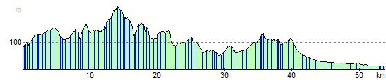
Elevation Profile