Millennium Way
41 miles (66 km)

 Travel across the width of Staffordshire and visit Stafford, Colwich, Rugeley, Yoxall and Barton Under Needwood on this splendid walk.
Much of the walk follows the Staffordshire and Worcestershire Canal and the Trent and Mersey Canal making for a pleasant and fairly easy waterside walk.
Millennium Way Ordnance Survey Map  - view and print off detailed OS map
Millennium Way Open Street Map  - view and print off detailed map
Millennium Way OS Map  - Mobile GPS OS Map with Location tracking
Millennium Way Open Street Map  - Mobile GPS Map with Location tracking
Further Information and Other Local Ideas
For more walking ideas in the area see the Staffordshire Walks page.
Cycle Routes and Walking Routes Nearby
Photos

The Millennium Way by Broadhill, Staffordshire

Trent and Mersey Canal at Branston, Staffordshire. Taken from Branston Bridge, No 34 on a damp and murky day. Ahead, and to both sides of the canal is Branston Water Park, a group of large flooded former gravel pits. Staffordshire's long distance footpath, The Millennium Way, passes along the tow-path here.

Bridge over the trail near Gnosall Heath.

RAFA Memorial, NMA. The eagle with outstretched wings perched on a globe is the emblem of the Royal Air Forces Association. It stands just off Millennium Way in the National Memorial Arboretum between Alrewas and Croxall.
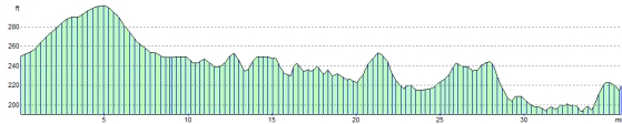
Elevation Profile