Aislabie Walk

 This walk follows a circuit that connected the estates and gardens of the Aislabie family in the 18th century.
You will visit the picturesque landscapes of Studley Royal, Laver Banks and Hackfall Woods on this delightful circular walk which takes place near the Yorkshire city of Ripon.
The main highlight of the walk is the National Trust owned Studley Park and Fountains Abbey. A designated World Heritage Site which has an area of 323 hectares (800 acres) and features an 18th century landscaped garden, some of the largest Cistercian ruins in Europe, a Jacobean mansion and a Victorian church designed by William Burges. It was developed around the ruins of the Cistercian Fountains Abbey.
Please click here for more information
Aislabie Walk Ordnance Survey Map  - view and print off detailed OS map
Aislabie Walk Open Street Map  - view and print off detailed map
Aislabie Walk OS Map  - Mobile GPS OS Map with Location tracking
Aislabie Walk Open Street Map  - Mobile GPS Map with Location tracking
Pubs/Cafes
The Queen's Head is located on the Main Street in the village of Kirkby Malzeard at postcode HG4 3RS for your sat navs. They serve good food with parking and a garden available. They are also dog friendly.
Cycle Routes and Walking Routes Nearby
Photos

Studley Royal church

The Lake, Studley Royal

River Laver

Hackfall Rustic Ruin
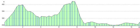
Elevation Profile