Angle Tarn

 This walk climbs to Angletarn Pikes from Patterdale in the Lake District. The area is a favourite of many with Angle Tarn considered one of the most beautiful spots in the Lake District. Alfred Wainwright described it as 'among the best of Lakeland tarns'. On the walk you will also enjoy super views over Ullswater Lake and the surrounding fells.
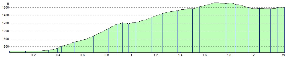
The walk starts at the parking area in Patterdale and climbs to Boredale Hause. You continue to Stony Rigg and then on to Angletarn Pikes. The Pikes are named after the two rocky towers at the summit, separated by a long section of peaty bog. From here there are great views down to Angle Tarn and over to the Helvellyn range and the Far Eastern Fells across Martindale. You then descend to the tarn for a waterside section before returning to Patterdale on the same route. Alternatively, you could continue past the tarn and head towards The Knott and Hayeswater to extend your walk. Brothers Water is also nearby and is another good walk to try in the area.
Angle Tarn Ordnance Survey Map  - view and print off detailed OS map
Angle Tarn Open Street Map  - view and print off detailed map
Angle Tarn OS Map  - Mobile GPS OS Map with Location tracking
Angle Tarn Open Street Map  - Mobile GPS Map with Location tracking
Pubs/Cafes
After your walk head to the White Lion Inn in Patterdale for some well earned refreshments. The pub has an interesting history having existed since the early 1800s. It's said that Wordsworth was in the bar as news arrived that Nelson had died at Trafalgar in 1805. The interior is full of old world charm while outside there's a nice beer garden just across the road. It's a lovely place to relax and soak in the fine views if the weather is good. You can find the pub in the village at postcode CA11 0NW for your sat navs.
Dog Walking
It's a great walk for fit dogs and the White Lion Inn mentioned above is also dog friendly.
Further Information and Other Local Ideas
The more strenuous climb to St Sunday Crag starts from Patterdale too. From here there's fabulous views of the Helvellyn range, High Street and the lake below.
You can also pick up the Ullswater Way and explore the area around the large lake. Here you can try the popular Glenridding to Aira Force Walk and visit a wonderful waterfall and woodland area. The Howtown to Glenridding Walk can also be picked up in nearby Glenridding. The easy trail follows the lakeshore to Howtown Pier where the Ullswater Steamer boats dock.
For more walking ideas in the area see the Lake District Walks page.
Cycle Routes and Walking Routes Nearby
Photos

Looking west across Angle Tarn towards Helvellyn and Catstye Cam.

With Satura Crag to the left and Brock Crags to the right.

Angle Tarn Path. With Place Fell in the distance.

Esk Pike from Angle Tarn. Beyond the outflow is the recently repaired path to Esk Hause

Cairn, Angletarn Pikes

Angletarn Pikes. This is the 565m summit.

White Lion at Patterdale - a nice place for a drink and a bite to eat

Boredale Hause. Looking towards Sheffield Pike
Elevation Profile