Orkneys Walks

Use the links to view full route information including elevation profiles, interactive maps and GPS downloads.
You can also view an overview map of all the routes in the using the Orkneys Walk Map>>
| Route Name | Photo | Distance | Description |
| Broch of Gurness | 1 miles (1 km) | Visit this Iron Age broch village on Mainland Orkney and learn about its fascinating history stretching back over 2000 years. View Full Details>> | |
| Brough of Birsay | 3 miles (5 km) | Visit this tidal island on this short walk on Mainland Orkney. View Full Details>> | |
| Marwick Head | 3 miles (5 km) | This RSPB Nature Reserve has some splendid coastal scenery and the largest cliff-nesting seabird colony on Orkney Mainland. Walk along the red sandstone cliffs and look out for up to 25,000 breeding seabirds. The walk also visits The Kitchener Memorial which commemorates Lord Kitchener and the crew of HMS Hampshire, which struck a mine and sank nearby on 5 June 1916. Parking is available at route start at the Marwick Bay car park. If you would like to continue your walk then the Brough of Birsay is just a mile or so up the coast from Marwick Head. View Full Details>> | |
| Mull Head | 4 miles (6 km) | This circular walk visits the Mull Head Nature Reserve on Mainland Island in the Orkney Islands. View Full Details>> | |
| Old Man of Hoy | 5 miles (8 km) | This walk takes you to the amazing 449-foot sea stack on the island of Hoy in the Orkney Islands. View Full Details>> | |
| Ring of Brodgar | 2 miles (4 km) | This walk visits a section of the fascinating Heart of Neolithic Orkney World heritage Site on Mainland island. The settlements are in a beautiful spot, next to the Loch of Stenness and surrounded by heather and wildlfowers. The area is also a RSPB Reserve with lots of wildlife to see. Look out for Curlews, drumming snipe, lapwings, dunlins, redshanks and oystercatchers as you make your way around the site. The notable ring of stones stands on a small isthmus between the Lochs of Stenness and Harray. They are the northernmost circle henge in Britain and the third largest. It is thought to have been erected between 2500 BC and 2000 BC. After exploring the site you can head south east for just over half a mile and visit the Standing Stones of Stenness. The stones may be the oldest henge site in the British Isles. Based on radiocarbon dating, it is thought that work on the site had begun by 3100 BC. Just next to the stones you will find Maeshowe. The Neolithic chambered cairn and passage grave dates from around 2800 BC. It's an impressive sight and one of the largest tombs in Orkney. The mound encasing the tomb is 115 feet (35 m) in diameter and rises to a height of 24 feet (7.3 m). You can extend your walk by heading to Skara Brae and the Bay of Skaill. You can virtually explore the area on the google street view link below! View Full Details>> | |
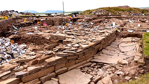
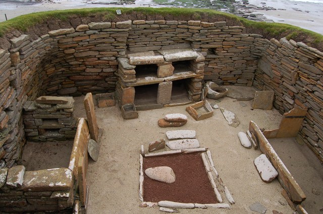
| Skara Brae and the Bay of Skaill | 1 miles (2 km) | Visit this fascinating Neolithic settlement located on Mainland in the Orkney Islands. The settlement is located on the beautiful Bay of Skaill and is designated as a UNESCO World Heritage Site. Skara Brae dates from 3180 BCE–2500 BCE and consists of eight clustered houses with stone bed enclosures, dressers and seats. The site is superbly preserved and referred to as the Scottish Pompeii. There are good facilities with a visitor centre and cafe. The walk also takes in some wonderful coastinline. You could continue your walk along the coast towards Yesnaby and Neban Point. Another must see site is the Ring of Brodgar. The notable ring of stones stands on a small isthmus between the Lochs of Stenness and Harray. It also includes the Standing Stones of Stenness and Maeshowe burial chamber. View Full Details>> |