Loch Lomond and the Trossachs Walks

Use the links to view full route information including elevation profiles, interactive maps and GPS downloads.
You can also view an overview map of all the routes in the using the Loch Lomond and the Trossachs Walk Map>>
| Route Name | Photo | Distance | Description |
| Aberfoyle | 14 miles (22 km) | This village in Stirling is located in a lovely spot on the River Forth at the foot of Craigmore mountain in the Loch Lomond and the Trossachs National Park. View Full Details>> | |
| Arrochar | 5 miles (8 km) | This circular walk explores the area around the village of Succoth, just to the west of Arrochar. There's nice views over Loch Long and the surrounding mountains. You can catch the train to Arrochar from Glasgow on the West Highland Line. The journey is less than 1.5 hours and is also a direct service. The walk starts from Arrochar and Tarbet train station where you can pick up the Three Lochs Way waymarked trail and follow it towards Stronafyne and then on to Succoth. You can then follow a waymarked, circular trail through woodland around the village. You'll enjoy fine views of Glen Loin, Loin Water, Loch Long and Ben Lomond as you make your way along the path. To continue your walking in the area climb to The Cobbler Mountain in the Arrochar Alps. Also known as Ben Arthur, the climb to the summit starts near Succoth and heads in a north westerly direction. The Cowal Way also passes the village. The waymarked trail visits Loch Fyne, the Kyle of Bute and Loch Ruel. View Full Details>> | |
| Balloch Castle Country Park | 3 miles (4.5 km) | Enjoy spectacular views of Loch Lomond in this beautiful country park in West Scotland. There are 200 acres to explore with nature trails, guided walks, peaceful woodland, a delightful walled garden and Balloch Castle which now serves as the visitor centre. You can stroll along the shoreline of the loch and then visit the Chinese Garden, Quarry Pond and the Secret Garden before enjoying refreshments at the loch side kiosk. The Three Lochs Way runs past the park so this is a great option if you would like to continue your walk/cycle. View Full Details>> | |
| Balmaha Forest | 1 miles (2 km) | This walk takes you along Loch Lomond, through woodland to Craigie Fort. The walk starts from the Balmaha car park/visitor centre where there's plenty of parking. It's a short climb along peaceful woodland trails to the fort where there are super views across the loch. If you would like to continue your walk in this area then you could climb Conic Hill for great views over the loch. You could also catch the ferry to Inchcailloch Island and enjoy nature trails and a little beach. View Full Details>> | |
| Balmaha to Milarrochy Bay and Rowardennan | 7 miles (11.2 km) | This walk follows a popular section of the West Highland Way from Balmaha to Rowardennan via Milarrochy Bay. View Full Details>> | |
| Beinn Dubh | 4 miles (6.5 km) | This is a lovely walk to try if you are visiting the pretty Luss Village in the Loch Lomond and the Trossachs National Park. The short climb gives fabulous views over the surrounding area. The walk starts in Luss at the car park and visitor centre. You then follow a footpath out of the village through some woodland before climbing Beinn Dubh on a nice grassy path. There are simply wonderful views of Loch Lomond, Glen Luss and the Arrochar Alps to enjoy. You can return the same way or continue to Mid Hill along the Glen Striddle Horseshoe. View Full Details>> | |
| Ben Ledi | 4 miles (7 km) | Climb to this popular viewpoint on this challenging walk in the Trossachs. The mountain gives fabulous views over the woodland and lochs of the Queen Elizabeth Forest Park. There's a car park at Creag Dhubh, just off the A84, about 2 miles west of Callander. From here you can pick up the tracks to take you through woodland and then up on to the mountain peak. It's about a 2.5 climb from the car park to the 879 m (2,884 ft) summit of Ben Ledi. There's fabulous views of Loch Lubnaig and Callander, while on a clear day you can see as far as the Wallace Monument and Stirling Castle. There's also splendid views of some of the most famous mountains of the area including Ben Lawers and Ben Lomond. To extend your exercise in the area you could enjoy a waterside cycle or walk along Loch Lubnaig and visit the delightful Falls of Leny on the way. The Rob Roy Way also passes through the area so you could futher explore the Queen Elizabeth Forest Park by picking up the trail and visiting Loch Venachar and Loch Drunkie. View Full Details>> | |
| Ben Lomond | 7 miles (11.5 km) | Climb one of Scotland's most popular munros on this challenging walk in the Loch Lomond and the Trossachs National Park. The mountains sits on the eastern shore of Loch Lomond rising to a height of 974 metres (3,196 ft). The climb takes place on a good path with a steady gradient, starting from the Rowardennan car park. The first section takes you through woodland towards Coire Corrach. You continue the ascent to Sron Aonaich and Sithean before reaching the summit where there are fabulous views across Loch Lomond & the Trossachs National Park. If you would like to continue your walking in the area then you pick up the West Highland Way and enjoy a walk along Loch Lomond. View Full Details>> | |
| Ben Lui | 5 miles (8 km) | Climb to the 1,130 m (3,710 ft) summit of this famous Munro in the Loch Lomond and the Trossachs National Park. The peaks of Ben Lui are designated as a National Nature Reserve with lush mountain vegitation including saxifrages, mosses and lichens. View Full Details>> | |
| Ben Venue | 9 miles (14 km) | This challenging walk climbs the popular mountain of Ben Venue in the Trossachs. There's fabulous views over the surrounding mountains, lochs and forestry from the high points. The route starts from the Ben Venue car park off the A821 at the western end of Loch Achray. From here you can pick up woodland trails along Achray Water to Gleann Riabhach. As you ascend the mountain you can enjoy wonderful views back down to the huge Loch Katrine and Loch Venachar. There's also far reaching views of the area's other mountains, particularly Ben Lomond. At the 729 m (2,392 ft) summit you can see as far as the Firth of Forth, the Isle of Arran and the Paps of Jura on a clear day. See the drone footage video below to appreciate the majestic surroundings. The mountain sits in the wonderful Queen Elizabeth Forest Park where there are miles of other cycling and walking trails to try. For example you can extend your exercise by following the wonderful cycle and walking path along the northern side of Loch Katrine. Glen Finglas is also nearby. Here you can enjoy woodland trails, open heathland, rushing streams, waterfalls and challenging hill climbs. View Full Details>> | |
| Bracklinn Falls and Callander Crags | 3 miles (5 km) | Enjoy a walk around this popular beauty spot in Callander in the Loch Lomond and the Trossachs National Park. These wonderful steep falls are set in a beautiful wooded gorge on Keltie Water, just a short walk from the town of Callander. The walk starts at the car park near the falls and follows a good path through woodland to Bracklinn Falls Bridge where there are great views of the foaming river. You continue on the woodland trails on the eastern side of the river before crossing a bridge and following a country lane back to the car park. There's great views of the surrounding Stirlingshire countryside and hills for much of the walk too. View Full Details>> | |
| Conic Hill | 2 miles (3.5 km) | This popular climb to Conic Hill gives wonderful views over Loch Lomond. The hill is situated above Balmaha and can be reached by following a good, stepped path along the West Highland Way to the summit. The walk starts from the Balmaha car park/visitor centre and heads through the woodland of the Balmaha plantation before climbing the wooden steps and following grassy paths to Conic Hill. The views back over Loch Lomond towards the Arrochar Alps and Ben Lomond are stunning. You can descend the same way or extend your walk by continuing along the West Highland Way to the Burn of Marr and Milton of Buchanan. This would turn the route into a longer circular walk. View Full Details>> | |
| Cowal Way | 57 miles (92 km) | This stunning walk starts at Portavadie on the banks of Loch Fyne and heads to Inveruglas. View Full Details>> | |
| Duncryne Hill | 1 miles (1.5 km) | This short climb takes you to the top of Duncryne hill near Gartocharn in the Loch Lomond and the Trossachs National Park. The hill is known as the 'Dumpling ' and stands at a modest height of 465 ft (142 m) giving wonderful views towards Loch Lomond. You can park by the roadside on Duncryne Road where you will find a gate and a good footpath leading through woodland to the hill. You follow the path to the hill summit where you will find a triangulation point. From here there are fabulous views over the Loch, its islands and the surrounding mountains of Ben Lomond and The Cobbler. View Full Details>> | |
| Falls of Dochart | 1 miles (2 km) | This short walk takes you from the village of Killin to the beautiful Falls of Dochart. You start in the village centre and follow a footpath through the town and along the River Dochart to the falls. It's a lovely setting with the white water crashing against rocks and flowing around the pretty Islands of Inchbuie. The river is surrounded by attractive woodland, with the lovely backdrop of the Highland Mountains. You can also visit the old watermill and cross the pretty little bridge over the river for even better views in both directions. The Falls are located at the western end of Loch Tay so it's easy to extend your walk and visit the loch from Killin. The long distance Rob Roy Way walk also runs past the falls so you could pick this up to extend your outing. View Full Details>> | |
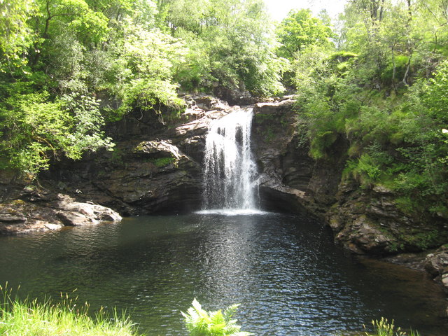
| Falls of Falloch | 1 miles (1 km) | Visit these beautiful 'hidden' waterfalls on this short walk in the Loch Lomond and the Trossachs National Park. The falls are located on the River Falloch in Glen Falloch, a few miles north of Loch Lomond. The walk starts from the car park just off the A82 and follows a path through woodland to the falls. It's a delightful beauty spot with picnic benches and views of the River Falloch. View Full Details>> | |
| Falls of Leny | 2 miles (4 km) | Visit these beautiful falls on this short walk from Callander in the Loch Lomond and the Trossachs National Park. You can follow a cycling and walking trail along a dismantled railway line from Callander to the falls. It's about a 2.5 mile walk along the Garbh Uisge river and the forestry of Queen Elizabeth Forest Park. It's a splendid short route with the rushing waters of the river and views of Ben Ledi and the other surrounding mountains. You can extend your walk by continuing north and visiting Loch Lubnaig. Just to the west of Callander there's another nice trail running along Loch Venachar and Loch Drunkie. View Full Details>> | |
| Flanders Moss Nature Reserve | 1 miles (1 km) | This delightful National Nature Reserve near Kippen has a 0.5 mile boardwalk trail to follow over the peat bogland. It's a fascinating and beautiful spot with sphagnum moss, heather, birches and cotton grass. View Full Details>> | |
| Glen Finglas | 11 miles (18 km) | Enjoy a walk along Glen Finglas Reservoir and Finglas Water on this lovely walk in the Trossachs. The glen consists of miles of attractive woodland trails, open heathland, rushing streams, waterfalls and challenging hill climbs. There's lots of wildlife to look out for including red deer, golden eagles and black grouse. You can park at the Glen Finglas car park to start your walk. From here you can pick up the waymarked trail to the reservoir. It follows the River Turk north before heading along the eastern side of the lake to Finglas Water. To extend your walk you can climb further into Glen Meann on the Mell trail. The circular trail runs for 15 miles and is suitable for mountain bikes and walkers. The cycling and walking trail along Loch Venachar and Loch Drunkie is also just to the south of the Glen. If you head west then you can visit Loch Achray and Loch Katrine. View Full Details>> | |
| Glen Ogle | 8 miles (12.8 km) | This lovely cycling and walking trail takes you along National Cycle Route 7 through the beautiful Glen Ogle. The route runs for about 8 miles along a traffic free path following the course of the former Callander and Oban Railway from Killin to Loch Earn. There's a moderate climb in the first half of the route before descending to the loch. On the way you'll enjoy views of the Ogle Burn and the pretty Lochan Lairig Chaile. The route starts on the Bridge of Dochart in the village of Killin, situated at the western head of Loch Tay in Stirling. The village is home to the wonderful Falls of Dochart, a major scenic highlight of the area. From here you can pick up the railway trail heading south west into the woodland of the glen. The trail takes you south, passing the still waters of Lochan Leirig Chaile to Lochearnhead at the foot of Glen Ogle. View Full Details>> | |
| Inchcailloch Island | 2 miles (3 km) | Follow the lovely nature trail around this picturesque small island on Loch Lomond. View Full Details>> | |
| Inchmahome Priory and Lake of Menteith | 1 miles (1 km) | Enjoy a stroll around Inchmahome Island on Lake Mentieth and explore the fascinating Inchmahome Priory. View Full Details>> | |
| Inversnaid Falls | 1 miles (2 km) | Visit these beautiful falls next to Loch Lomond on this short walk. The route starts at the Inversnaid Hotel before a short stroll takes you to the falls on Arklet Water. You can then continue your walk by climbing through the surrounding woodland and heading along the loch using the West Highland Way. You could also extend your walk by visiting the RSPB Inversnaid Nature Trail where you can look out for a variety of wildlife. View Full Details>> | |
| Inversnaid Nature Trail | 1 miles (2 km) | Follow the lovely nature trail in this RSPB reserve by Loch Lomond on this short walk. The route starts at the Inversnaid Hotel and follows the West Highland Way along the loch before climbing to oak woodland and open moorland where there are fabulous views. Look out for pied flycatchers, buzzards and woodpeckers on the way. If you would like to extend your walk you could continue along the West Highland Way in either direction. You could also visit the beautiful Inversnaid Falls which are a short stroll from the start of this route. View Full Details>> | |
| Killin | 5 miles (8.2 km) | This popular Perthshire village is located in a fine spot at the western end of Loch Tay in the Loch Lomond and the Trossachs National Park. View Full Details>> | |
| Loch Achray | 1 miles (1.5 km) | This walk visits the beautiful Loch Achray in the Loch Lomond and the Trossachs National Park. View Full Details>> | |
| Loch Ard | 4 miles (6 km) | Enjoy a walk or cycle along the beautiful Loch Ard, near Aberfoyle in the Loch Lomond and the Trossachs National Park. This circular route starts in the car park at the eastern end of the loch and takes you along the loch and through the surrounding woodland on good paths. On the way there are lovely view points with picnic benches where you can sit and admire the view over Loch Ard to the forests and surrounding hills. The route also passes a number of interesting sculptures with riddles and the pretty Lochan Ghleannain. You can easily extend your outing by continuing west along the miles of cycle and walking trails in the Loch Ard Forest. The Forestry Commision have created a number of fine waymarked trails to try including the Ben Lomond Viewpoint Trail and the Loch Ard Sculpture Trail. There are also great cycling and walking trails to Loch Katrine, Loch Achray and Loch Venachar and Loch Drunkie. View Full Details>> | |
| Loch Arklet | 10 miles (16 km) | This walk takes you through the lovely Glen Arklet in the Loch Lomond and the Trossachs National Park. On the way you will enjoy great views of Loch Arklet and pass the pretty Inversnaid Falls on Arklet Water. The route starts at the Inversnaid Hotel on the banks of Loch Lomond, before a short stroll takes you to the lovely Inversnaid falls on Arklet Water. You continue by climbing through the surrounding woodland along Arklet Water to Loch Arklet. There are splendid views back towards Loch Lomond. The path continues above Loch Arklet through Glen Arklet, before finishing at the pier on Loch Katrine. You could extend your walk by continuing along the super lochside path at Loch Katrine or head back to Inversnaid on the same path. View Full Details>> | |
| Loch Chon | 6 miles (9 km) | This circular walk takes you around Loch Chon and the Loch Ard Forest in the Loch Lomond and the Trossachs National Park. View Full Details>> | |
| Loch Earn | 3 miles (5.5 km) | Explore the eastern end of Loch Earn and climb to a lovely viewpoint on this short walk. You can start the walk from the car park on the St Fillans Road just to the east of St Fillans. From here you can climb up to the viewpoint above the loch, passing through the woodland of St Fillans Park. There's splendid views over the beautiful loch to Ben Vorlich from this elevated spot. After taking in the views the route descends towards St Fillans before following the lochside road back to the car park. View Full Details>> | |
| Loch Eck | 14 miles (22 km) | This walk follows a trail along the western side of the stunning Loch Eck in the Loch Lomond and the Trossachs National Park. The walk starts at Glenbranter in the Argyll Forest Park where there is a forestry commission car park. It's located just to the south of Loch Fyne and is a great place to start a whole range of cycle rides and walks. From the car park you can pick up the trails heading south to the loch with views of the River Cur on the way. On the route you'll enjoy attractive pine woodland as you make your way through the Loch Eck Forest. On the lochside paths there's also lovely views across the loch to the surrounding hills. It's a very peaceful and tranquil place, ideal for a relaxing walk in beautiful scenery. At the southern end of the loch you will find the Benmore Botanical Gardens where there's a world-famous collection of plants from the Orient and the Himalaya to North and South America. To continue your walking in the area head east to Ardentinny where you can pick up a waymarked trail on the western side of Loch Long. Just to the south of the Benmore Botanical Gardens you will find the delightful Pucks Glen where there's a lovely trail through a wood gorge with a burn and waterfalls. View Full Details>> | |
| Loch Katrine | 13 miles (21 km) | This super cycle and walking route takes you on the lochside path around Loch Katrine in the Loch Lomond and the Trossachs National Park. You start off at the Trossachs Pier and Visitor centre at the south eastern end of the loch where cycle hire is available. You then pick up the excellent tarmac path which starts off fairly flat but does have some climbs along the way. There are great views over the loch and to the surrounding hills and mountains. You'll also pass Glengyle House, the birthplace of Robert Roy MacGregor, the Scottish outlaw and folk hero. The path runs for about 13 miles through woodland and countryside to Stronachlachar on the western side of the loch. Here you can catch the ferry back to Trossachs Pier or if you'd like to extend your outing head to the nearby Loch Arklet or Loch Ard. There's also another great cycling and walking trail along Loch Venachar and Loch Drunkie. Just to the east you will find Glen Finglas where you can enjoy a waymarked walk to the Glen's rivers, streams, waterfalls and reservoir. The climb to Ben Venue also starts from the car park at Loch Achray, close to Loch Katrine. It's a popular walk with great views back down to the lochs. View Full Details>> | |
| Loch Long | 3 miles (5.2 km) | This circular walk follows two delightful waymarked trails on the western side of Loch Long at Ardentinny in the Loch Lomond and the Trossachs National Park. The walk starts in the pretty little village of Ardentinny on the western shores of the expansive loch. Here you can pick up the Laird's Trail and follow it north along the loch. The trails then head up into the woodland surrounding the loch. They'll take you back to the village on nice woodland trails, crossing the Glen Finnart Burn on the way. After your exercise you can enjoy refreshments in The Ardentinny pub. The contemporary Scottish bar & Italian bistro has a wonderful outdoor decking area with fabulous views over the loch. The site has a rich history, with parts of the building dating back to the late 1600’s, originally serving as a place where the Dukes of Argyll waited for the ferry whilst travelling between castles in Dunoon and Rosneath. You can continue your walking in the area by heading west and visiting Loch Eck. There's a nice trail running along the western side of the loch and the beautiful Benmore Botanical Gardens at the southern end. Also nearby is the delightful Pucks Glen where there's a lovely trail through a wood gorge with a burn and waterfalls. View Full Details>> | |
| Loch Lubnaig | 9 miles (15 km) | This cycling and walking route follows National Cycle Route 7 from Callander to Strathyre along Loch Lubnaig. It's a great traffic free path, running for just over 9 miles along the Garbh Uisge river before heading through the woodland of Queen Elizabeth Forest Park alongside the loch. The route finishes at the little village of Strathyre at the northern end of the water. It's a lovely area with the beautiful loch surrounded by attractive forestry and the mountains of the Trossachs. You'll also pass the wonderful Falls of Leny at the Callander end of the loch. The loch is popular with fishermen while canoes can be rented at the north end. Car parks are available at the southern end of the water. It's easy to extend your cycling and walking in this beautiful area. You could head a few miles west of Callander and visit Loch Venachar and Loch Drunkie. . If you are looking for a more challenging walk then you could climb to Ben Ledi for fabulous views back down to the loch. View Full Details>> | |
| Loch Rusky | 1 miles (2 km) | This quiet little loch is located in a lovely spot in the Loch Lomond and the Trossachs National Park. View Full Details>> | |
| Loch Sloy | 1 miles (1 km) | This walk visits the photogenic Loch Sloy Dam at the southern end of Loch Sloy. View Full Details>> | |
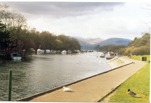
| Loch Tay | 2 miles (4 km) | Enjoy a short walk to Loch Tay from the town of Killin in the Loch Lomond and the Trossachs National Park. The walk starts at the parking area in Killin and crosses the River Lochay on an old railway bridge. You continue along the now disused railway line through woodland to the loch. From here you can enjoy pretty little beaches and wonderful views across the loch to the surrounding hills and mountains. You can return to the car park or extend your walk by heading along the River Dochart to the beautiful Falls of Dochart which is a short walk away. The Rob Roy Way also passes through Killin so you could also extend your outing on this long distance footpath. View Full Details>> | |
| Loch Venachar and Loch Drunkie | 19 miles (30 km) | This route in Queen Elizabeth Forest Park follows National Cycle Route 7 through the Achray Forest to two beautiful lochs in the Loch Lomond and the Trossachs National Park. The route starts in the village of Aberfoyle and follows good woodland paths to Lochan Reoidhte and then on to Loch Drunkie. You continue on more forest tracks before a long lochside stretch along Loch Venachar. There's great views across the water to the surrounding woodland, hills and mountains. If you'd like to explore the area further then you can head to the nearby Loch Katrine for more wonderful waterside cycling and walking trails. Loch Ard also has some great woodland cycle and walking trails while the fascinating Inchmahome Priory is only a few miles east of Aberfoyle. Just to the north of Loch Venachar you can pick up a nice waymarked trail through Glen Finglas. Here you will find rivers, streams, waterfalls and the lovely Glen Finglas Reservoir. The walk to Ben Venue also starts from near to Loch Achray, just to the west of Loch Venachar. It's a popular climb with great views back down to the loch. View Full Details>> | |
| Loch Voil | 9 miles (14.5 km) | This walk visits Loch Voil and Loch Doine from the village of Balquhidder in the Loch Lomond and the Trossachs National Park. There's a nice, quiet country lane heading west from the village to the two beautiful lochs. It's a fairly flat path with some sections running right alongside the water. Along the way there's great views across the still waters to the park's forests, hills and mountains. It's about a 4.5 mile walk to the end of Loch Doine so around 9 miles there and back. View Full Details>> | |
| Lochgoilhead and Loch Goil | 3 miles (4.2 km) | The expansive Loch Goil is located within the Loch Lomond and the Trossachs National Park on the Cowal peninsula in Argyll and Bute. It is an arm of Loch Long. View Full Details>> | |
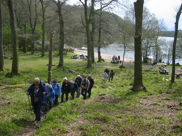
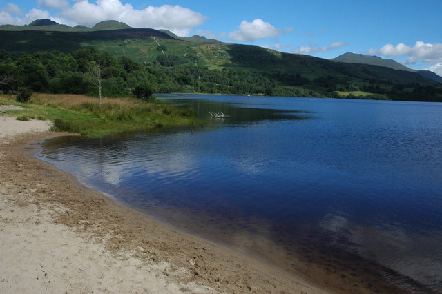
| Luss Village | 1 miles (2 km) | Enjoy an easy circular walk around this delightful conservation village on the western shore of Loch Lomond. If you're visiting the Loch Lomond and the Trossachs National Park then Luss is one of the must see areas. You can catch boat trips from the pier, stroll along the pretty beach and then explore the delightful village with its pretty sandstone and slate cottages. This walk starts at the pier and follows the Luss Heritage Trail through the village to a small woodland area where you pick up a lovely riverside path. This leads you past pretty weirs to the loch, where you will pass the 19th century parish church before returning to the pier. It's a pleasant, varied walk with great views of the loch and woodland, river and lochside sections. If you'd like to extend your walk then you could climb the nearby Beinn Dubh for wonderful views over Glen Luss and Loch Lomond. View Full Details>> | |
| Pucks Glen | 2 miles (2.5 km) | This delightful wooded glen is one of the most popular walks in the area. It's very pretty area with a rushing burn, pretty waterfalls and lots of interesting vegetation. You can start the walk at the car park, located just off the A815, north west of Holy Loch. From here you can pick up the footpaths heading east through the attractive gorge with its mosses, ferns and rhododendrons. Along the way there's picturesque footbridges and steps to help you navigate the area. There's also a bird hide where you can look out for the many winged visitors to the area. The circular trail runs for about 1.5 miles but there are also woodland trails branching of it different directions. You could follow them south east to Holy Loch for example. View Full Details>> | |
| Queen Elizabeth Forest Park | 3 miles (5 km) | Enjoy miles of mountain bike trails and footpaths in this expansive forest in Perthshire. This 3 mile circular walk take you around the Lime Craig Trail from the excellent visitor centre in Aberfoyle. There's attractive oak woodland, waterfalls and a steep climb to Lime Craig. From the viewpoint there are excellent views of Ben Lomond, Ben Venue, Ben Ledi, the Carse of Stirling and the Campsie Fells. The area is great for wildlife too. Look out for red squirrels and crossbills as you make your way through the woods. There's lots of other trails to try with more details from the Lodge Visitor Centre. This route is designed for walkers but there's plenty of trails for mountain bikers to try. For example you can follow the National Cycle Route 7 to Loch Venachar and Loch Drunkie through the Archay Forest from the centre. If you head north west you can visit Loch Achray and the wonderful Loch Katrine. A few miles east of Aberfoyle you will find Inchmahome Priory on Lake Mentieth. It's a special place with the 13th century ruins of the priory surrounded by woodland trails. Just to the west of the visitor centre you can pick up the cycling and walking trails along Loch Ard. The Rob Roy Way long distance footpath also passes through Aberfoyle so you can pick this up to head deeper into the forest. If you were to head north east along the path it would take you to Callander where you can visit the beautiful Falls of Leny and Loch Lubnaig. If you are looking for a more challenging walk then you could climb to Ben Ledi for fabulous views over the park. View Full Details>> | |
| Rob Roy Way | 79 miles (127 km) | Follow in the footsteps of Robert Roy MacGregor, famous Scottish folk hero and outlaw of the early 18th century. The walk takes you across the Southern Highland of Scotland taking in some of the most beautiful countryside in the UK. Starting from Drymen on the West Highland Way it goes north east to finish in Pitlochry. The path passes a series of beautiful Lochs including Loch Venachar, Loch Tay and Loch Earn. You will also pass a series of spectacular waterfalls such as the Falls of Dochart and The Falls of Moness. View Full Details>> | |
| Rowardennan to Inversnaid | 7 miles (11.1 km) | This walk follows a lovely section of the West Highland Way from Rowardennan to Inversnaid in the Loch Lomond and the Trossachs National Park. View Full Details>> | |
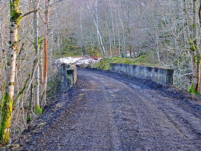
| St Fillans to Comrie Railway | 6 miles (9 km) | This walk takes you along the old St Fillans and Comrie Railway from St Fillans to Dalchonzie and Comrie. Along the way you'll pass the old stations and viaducts with views of the River Earn and the surrounding hills to enjoy as well. View Full Details>> | |
| The Cobbler Mountain | 6 miles (9 km) | The Cobbler or Ben Arthur is one of the most popular climbs in the highlands. At 884 m (2,900 ft) it is not the highest of the Arrochar Alps but is considered the most spectacular. View Full Details>> | |
| Three Lochs Way | 33 miles (53 km) | This super route is suitable for both walkers and mountain bikers. View Full Details>> | |
| West Highland Way | 93 miles (150 km) | This is a fabulous long distance walking and cycling* route from Milngavie, north of Glasgow, to Fort William in the Scottish Highlands. View Full Details>> |