 |
Erewash Valley Trail |
 |
|
Description |
 This splendid cycling and walking trail explores the canals, countryside, towns and villages of south Derbyshire and Nottinghamshire. It's a circular route with miles of great traffic free sections so it's ideal for families or anyone looking for a safe cycle ride. Walkers can also enjoy the nice surfaced trails along the canals and through the nature reserves on this varied route. This splendid cycling and walking trail explores the canals, countryside, towns and villages of south Derbyshire and Nottinghamshire. It's a circular route with miles of great traffic free sections so it's ideal for families or anyone looking for a safe cycle ride. Walkers can also enjoy the nice surfaced trails along the canals and through the nature reserves on this varied route.
As a circular route there are several options for a start point. This route starts at Trent Lock on the Erewash Canal just south of the town of Long Eaton. Trent Lock is a significant canal junction where the River Soar, the Trent and Mersey Canal, the River Trent and the Erewash Canal meet (you can virtually explore this section on the street view link below). You then follow the canal towpath north through the town of Long Eaton to Sandiacre. You continue to Ilkeston, passing Gallows Inn and the impressive Bennerley Viaduct, before coming to Langley Mill at the basin of the Erewash Canal. It's a nice section with lots of pretty locks, stone bridges and views of the River Erewash.
At Langley Mill you turn south and pick up the Nottingham Canal heading to Cossal and Trowell. The disused canal has now been declared as a nature reserve which attracts lots of dragonflies, damselflies and birdlife. The canal leads you towards Stapleford Hills and Bramcote Hills Park. The park includes a mix of woodland and parkland with a nice walled garden. You'll also pass the geologically fascinating Hemlock Stone. The stone is an outcrop of New Red Sandstone, deposited more than 200 million years ago in the Triassic Period. It's worth stopping to have a look at the plaque and stone on Stapleford Hill before continuing.
From the park you continue through Stapleford and Chilwell to the lovely Attenborough Nature Reserve. Here you'll find 350 acres of lakes, wetland, woodland, grassland and scrub with a huge variety of wildlife to look out for. The Beeston Canal can also be picked up at the eastern end of the reserve, next to the pretty Beeston Lock.
The final waterside section takes you along the River Trent to Trent Lock and the finish point. Towards the end of the route you pass along the Trent Valley Way so this is a good option if you would like to continue your walking in the area.
The trail also forms part of the Nutbrook Trail Cycle Route which runs along the Erewash Canal before bearing right near Stapleford and heading up to Shipley Country Park on a dismantled railway line.


|
|
|
Distance | 28 miles (45 km) |
|
|
Difficulty | ** |
|
|
Joining Routes | Erewash Canal, Trent Valley Way, Attenborough Nature Reserve, Nottingham Canal, Trent Lock, Ilkeston |
|
|
Memory Map Route | Erewash Valley Trail.mmo (right click - 'Save As') |
|
|
GPX File | Erewash Valley Trail.gpx (right click - 'Save As')
| |
|
Route Photos |  |  |  |  | Trent Lock | Langley Mill basin of the Erewash Canal | Nottingham Canal | Nottingham Canal at Trowell |  |  |  |  | Swancar Bridge, Nottingham Canal | Hemlock Stone | Bramcote Hills Park Arch | Attenborough Nature Reserve |
 Photos are copyrighted by their owners Photos are copyrighted by their owners
|
|
|
Map (Route in Red)
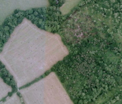
Aerial Photo View of this route
|
|
|
|
Video | |
|