 |
Leigh Woods |
 |
|
Description |
 Enjoy cycling and walking trails in this forest and nature reserve in Bristol. The reserve is located in the beautiful Avon Gorge and is a popular retreat from the city. You can enjoy oak, small leaf lime and ash forest with carpets of bluebells in the springtime.Ā Along the way you can enjoy sculpture trails, views of the River Avon and the Clifton Suspension Bridge and a variety of wildlife. Look out for bullfinch, marsh tit, song thrush and Peregrine falcon as you make your way through the woods. The area is managed by the National Trust so the trails are well maintained. Enjoy cycling and walking trails in this forest and nature reserve in Bristol. The reserve is located in the beautiful Avon Gorge and is a popular retreat from the city. You can enjoy oak, small leaf lime and ash forest with carpets of bluebells in the springtime.Ā Along the way you can enjoy sculpture trails, views of the River Avon and the Clifton Suspension Bridge and a variety of wildlife. Look out for bullfinch, marsh tit, song thrush and Peregrine falcon as you make your way through the woods. The area is managed by the National Trust so the trails are well maintained.
Walkers can enjoy various waymarked walking trails including the popular one-mileĀwoodland wander which will suit all abilities. The whole of the circular route below is designed for walkers. If you are on a bike please stick to the marked cycle trails which start from the same point as this route.
For cyclists there is a blue grade trail which makes for a nice traffic free ride for beginners or families. The video below shows this trail known as the Yer Tiz trail. There is also a red grade trail for more experienced mountain bikers to try. A National Cycle Network trail also runs through the forest.
Parking is available at the woods but you could follow the River Avon Trail from the centre of Bristol to extend your exercise. It's about a 2-3 mile walk/cycle along the river from the city centre and train station.
To extend your walk you can cross the river and visit the lovely Durdham and Clifton Downs.
Leigh Woods Postcode BS8 3PL
N.B Postcode may be approximate for some rural locations
Please click here for more information


|
|
|
Distance | 2 miles (3 km) |
|
|
Difficulty | * |
|
|
Joining Routes | Bristol Circular River Walk, River Avon Trail, Brandon Hill and Cabot Tower, The Downs Bristol, Clifton Suspension Bridge, Abbots Pool, Bristol Triangular City Walk, Blaise Castle |
|
|
Memory Map Route | Leigh Woods.mmo (right click - 'Save As') |
|
|
GPX File | Leigh Woods.gpx (right click - 'Save As')
| |
|
Route Photos |
 Photos are copyrighted by their owners Photos are copyrighted by their owners
|
|
|
Map (Route in Red)
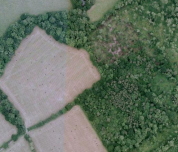
Aerial Photo View of this route
|
|
|
|
Video | |
|