 |
Bure Valley Path |
 |
|
Description |
 This walk and cycle track runs along Bure Valley Railway, and the River Bure from Aylsham to Wroxham. The route passes Brampton, Buxton and Coltishall with each having a station if you wish to rest your legs and take a trip on the railway. This walk and cycle track runs along Bure Valley Railway, and the River Bure from Aylsham to Wroxham. The route passes Brampton, Buxton and Coltishall with each having a station if you wish to rest your legs and take a trip on the railway.
The Bure Valley Railway is Norfolk's longest fifteen inch gauge line. It opened on 10th July 1990, and the long distance footpath running parallel with it was opened a year later in 1991. It's a nice flat path which runs for about 9 miles. As such it makes for a leisurely stroll or an easy cycle ride.
Please click here for more information


|
|
|
Distance | 9 miles (14 km) |
|
|
Difficulty | * |
|
|
Joining Routes | Wroxham, Blickling Hall, Aylsham, Marriot's Way, Coltishall, Marsham Heath, Hoveton, Rebellion Way |
|
|
Memory Map Route | Bure Valley Path.mmo (right click - 'Save As') |
|
|
GPX File | Bure Valley Path.gpx (right click - 'Save As')
| |
|
Elevation | 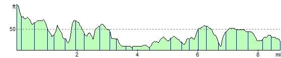
|
|
|
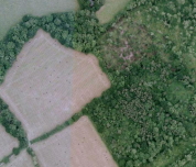
Route Photos |  |  |  |  | Bure Valley Railway and trackside path near Aylsham | The Mermaid near Burgh next Aylsham | Near Buxton | The path near Coltishall | | | | | | | | |
 Photos are copyrighted by their owners Photos are copyrighted by their owners
|
|
|
Map (Route in Red)
Aerial Photo View of this route
|
|
|
|
Video | |
|