 |
Marriot's Way |
 |
|
Description |
 This wonderful cycle and walking path runs from Aylsham to Norwich along the trackbeds of two former railway lines. The route passes Cawston, Reepham, Lenwade, the wildlife rich Taverham Mill and Drayton, taking you through the Wensum Valley with regular views of the River Wensum to enjoy. This wonderful cycle and walking path runs from Aylsham to Norwich along the trackbeds of two former railway lines. The route passes Cawston, Reepham, Lenwade, the wildlife rich Taverham Mill and Drayton, taking you through the Wensum Valley with regular views of the River Wensum to enjoy.
Along the way look out for a series of rail sculptures and lots of interesting flora and fauna. Wildlife includes butterflies, jays, magpies, green woodpeckers and wrens.
Cycle hire is available at Reepham station where there's also a nice cafe for refreshments.
Please click here for more information


|
|
|
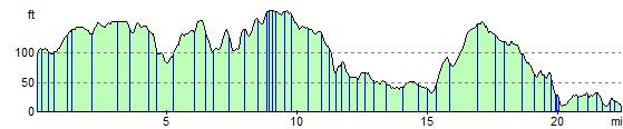
Distance | 22 miles (36 km) |
|
|
Difficulty | *** |
|
|
Joining Routes | Foxley Wood, Hellesdon Circular Walk, Norwich Riverside Walk, Reepham, Blickling Hall, Marsham Heath, Wensum Way, Rebellion Way, Norwich To Cromer, Taverham Mill |
|
|
Memory Map Route | Marriot's Way.mmo (right click - 'Save As') |
|
|
GPX File | Marriot's Way.gpx (right click - 'Save As')
| |
|
Elevation | 
|
|
|
Route Photos |  |  |  |  | Near Aylsham | Cawston | Reepham | Lenwade |  |  |  |  | River Wensum near Lenwade | Countryside at Attlebridge | Lovely section at Taverham | Near Drayton |
 Photos are copyrighted by their owners Photos are copyrighted by their owners
|
|
|
Map (Route in Red)
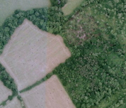
Aerial Photo View of this route
|
|
|
|
Video | |
|