Alban Way - St Albans to Hatfield Cycle Route Map
![]()
![]() Follow the disused Hatfield to St Albans railway line on this popular route from St Albans to Hatfield.
Follow the disused Hatfield to St Albans railway line on this popular route from St Albans to Hatfield.
It is a shared cycle and walk path and makes for an easy and safe stroll or ride. The route runs for about 6 miles with nice views of the countryside along the way.
If you enjoy this ride then you could also try the Cole Green Way. It's another traffic free rail trail running from Welwyn Garden City to Hertford.
See the St Albans Cycle Routes page for more rides around the area.
Alban Way Ordnance Survey Map  - view and print off detailed OS map
Alban Way Open Street Map  - view and print off detailed map
*New* - Walks and Cycle Routes Near Me Map - Waymarked Routes and Mountain Bike Trails>>
Alban Way OS Map  - Mobile GPS OS Map with Location tracking
Alban Way Open Street Map  - Mobile GPS Map with Location tracking
Pubs/Cafes
On the route you could stop off at the little hamlet of Sleapshyde and visit The Plough. It's a historic pub of some note with the primary alehouse dating back to 1690. There's a cosy interior featuring wooden beams, lime plastered walls, two fireplaces and low ceilings. Outside there's a lovely garden area and terrace where you can enjoy views of the surrounding fields with your meal. The inn is located just south of the route as you approach Nast Hyde Halt and Hatfield. You can find them on Sleapshyde Lane with a postcode of AL4 0SE for your sat navs.
Dog Walking
The path is nice for dog walking though on weekends it can get busy with cyclists. As such it's best to bring your dog on quieter days or keep them on leads if there are lots of bikes around. The Plough pub mentioned above is dog friendly.
Further Information and Other Local Ideas
To extend your exercise you could explore the extensive grounds of the historic Hatfield House. The grounds include several waymarked walking trails with woodland, parkland and gardens to see. It's also steeped in history having been the childhood home of Queen Elizabeth I.
On the northern outskirts of St Albans there's miles of good cycling and walking trails to be found around the Heartwood Forest near Sandridge.
For more walking ideas in the area see the Hertfordshire Walks page.
Visitor Reviews
"A pleasant, flat ride through old railway tracks, perfect for family outings. Loved spotting the abandoned stations along the way. Could use a few more signposts, though."
"Alban Way is ideal for commuting between Hatfield and St Albans. Smooth tarmac, no hills—just pure cycling joy. Great way to enjoy greenery without straying too far from civilisation."
"It’s lovely for a stroll, but the cyclists zoom by without warning. Be sure to keep pets on a leash. Nice bit of history with the old platforms, though!"
"Highly recommend for beginners and casual cyclists. It’s safe, traffic-free, and offers a glimpse into the area's railway past. Perfect on a sunny afternoon."
"Great trail, but some crossings can be tricky if you're not familiar with the route. That said, the peaceful atmosphere and lack of steep gradients make up for it!"
Cycle Routes and Walking Routes Nearby
Photos

Cmglee Alban Way cyclists

Alban Way. Ellenbrook recreation ground, Hatfield. Alban Way is a cycle and footpath which runs along the route of the old Hatfield to St Albans railway. The playground is on the corner of Alban Way and Ellenbrook Lane. The houses in the background are in Wilkins Green Lane.

Cmglee Alban Way arch

Hill End Lane bridge over the Alban Way

The Broadwater, Home Park, Hatfield House. This lake by the River Lea has a nice waterside walking trail to try. It's a fine place to relax after your exercise if you are coming from the St Albans end. Near the house look out for an oak tree with a plaque. It was planted by Queen Elizabeth II in 1985 on the site of the original tree where Queen Elizabeth I was thought to have heard of her succession to the throne in the 16th century.

St Albans Cathedral grounds. The grounds of the cathedral are a pleasant place for a stroll. The abbey itself is well worth exploring with architecture dating from Norman times. It has a fascinating history having previously been an abbey until its dissolution in the 16th century. It later became a cathedral in 1877. At 85 metres long, it has the longest nave of any cathedral in England.

A cyclist makes there way past the old Nast Hyde Halt platform on a lovely spring day in 2017. The station was opened in 1910 to serve the new houses being built in the area. It has now been lovingly restored with old notices, railway furniture and other railway memorabilia. It's a pretty spot and one of the highlights on the path.

A view of the surfaced path at Nast Hyde. The Hatfield & St Albans Railway opened their line through here, linking the two towns, in 1865. The railway was subsequently absorbed into the Great Northern Railway in 1883, but Nast Hyde Halt was not built until 1910. Passenger services on the railway were an early casualty of the pre-Beeching era of British Railways, closing just 3 years into Nationalization in 1951, with the halt obviously closing at the same time. Freight traffic on the line lingered into the 1960s, and the track was still in use in 1967.
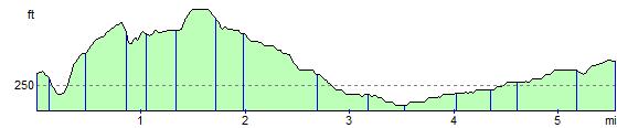
Elevation Profile