Bath to Frome

 Travel to the eastern tip of the Mendip Hills on National Cycle routes 4, 24 and 48.
The route starts on Pulteney Bridge near the centre of Bath and follows National Cycle Route 4 along the River Avon and the Kennet & Avon Canal before turning south west along National Cycle Route 24 near Monkton Combe. You'll then follow a series of quiet roads and a dismantled railway line on the Colliers Way to Radstock. This section runs along the Wellow Brook and has views of the Midford Hills and Midford Castle.
From here, the route turns south east along a disused railway track before a short on road section takes you into Frome. The route finishes with a spell along the River Frome with the route finishing near Frome train station.
Please click here for more information
Bath to Frome Ordnance Survey Map  - view and print off detailed OS map
Bath to Frome Open Street Map  - view and print off detailed map
Bath to Frome OS Map  - Mobile GPS OS Map with Location tracking
Bath to Frome Open Street Map  - Mobile GPS Map with Location tracking
Cycle Routes and Walking Routes Nearby
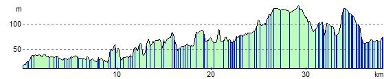
Elevation Profile