Bellingham to Berwick-upon-Tweed
78 miles (125 km)

 This long challenging cycle ride takes you along National Cycle route 68 and through the beautiful Northumberland National Park from Bellingham to Berwick-upon-Tweed.
The ride takes you through some lovely Northumberland countryside giving splendid views of the Cheviot Hills as you go. You will pass through the pretty villages of Elsdon, Harbottle and Wooler with lovely runs along the Rivers Till and Tweed to enjoy on your way.
The route passes along part of the epic Pennine Cycleway which can be used to further extend your ride.
Bellingham to Berwick-upon-Tweed Ordnance Survey Map  - view and print off detailed OS map
Bellingham to Berwick-upon-Tweed Open Street Map  - view and print off detailed map
Bellingham to Berwick-upon-Tweed OS Map  - Mobile GPS OS Map with Location tracking
Bellingham to Berwick-upon-Tweed Open Street Map  - Mobile GPS Map with Location tracking
Further Information and Other Local Ideas
The Reivers Route passes through Bellingham. The popular coast to coast ride crosses the country from Whitehaven to Tynemouth. The signed trail runs mostly along National Cycle Route 10.
Cycle Routes and Walking Routes Nearby
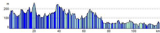
Elevation Profile