Birmingham to Lichfield
28 miles (45 km)

 This route follows National Cycle routes 5 and 54 through the West Midlands in to Staffordshire. You start near Birmingham New Street Station and head west along the Birmingham Canal. You then turn north towards West Bromwich passing through Sandwell Valley Country Park with its lovely woodlands and meadows.
The route continues onto Walsall where a dismantled railway line takes you onto Pelsall, crossing the Wyrley and Essington Canal. You continue north on and off road passing through Chasewater Country Park with its attractive lake. The route then turns east along National Cycle route 54 towards Burntwood finishing in Lichfield.
Birmingham to Lichfield Ordnance Survey Map  - view and print off detailed OS map
Birmingham to Lichfield Open Street Map  - view and print off detailed map
Birmingham to Lichfield OS Map  - Mobile GPS OS Map with Location tracking
Birmingham to Lichfield Open Street Map  - Mobile GPS Map with Location tracking
Cycle Routes and Walking Routes Nearby
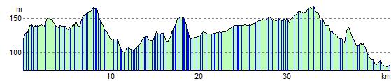
Elevation Profile