Boston to Wainfleet All Saints
22 miles (36 km)

 This ride takes you through the Lincolnshire countryside from Boston to Wainfleet All Saints. The route starts by the tourist information centre in Boston and begins with views of the Haven River. You then head through the countryside on country lanes to your destination passing through Butterwick and Friskney as you go. You finish near the train station at Wainfleet All Saints just after crossing the Wainfleet Haven River.
Boston to Wainfleet All Saints Ordnance Survey Map  - view and print off detailed OS map
Boston to Wainfleet All Saints Open Street Map  - view and print off detailed map
Boston to Wainfleet All Saints OS Map  - Mobile GPS OS Map with Location tracking
Boston to Wainfleet All Saints Open Street Map  - Mobile GPS Map with Location tracking
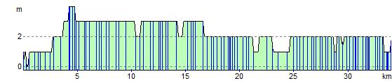
Elevation Profile