Cardiff to Pontypridd

 This lovely largely off road ride follows National Cycle Route 8 and the Taff Trail from Cardiff to
Pontypridd.
This lovely largely off road ride follows National Cycle Route 8 and the Taff Trail from Cardiff to
Pontypridd.
You start on the River Taff in Cardiff and head along the river northwards passing the Millennium Stadium and Cardiff Castle. There are also views of the attractive riverside Bute Park and the Weir on the Taff near Maindy as you leave the centre of Cardiff. You soon come to Radyr and then onto Castle Coch (the red castle) before passing through the village of Nantgarw. The ride continues along the river through Glyntaff and on to Pontypridd where you finish near the train station.
Cardiff to Pontypridd Ordnance Survey Map  - view and print off detailed OS map
Cardiff to Pontypridd Open Street Map  - view and print off detailed map
Cardiff to Pontypridd OS Map  - Mobile GPS OS Map with Location tracking
Cardiff to Pontypridd Open Street Map  - Mobile GPS Map with Location tracking
Further Information and Other Local Ideas
Just to the west of Pontypridd there's Barry Sidings Country Park at Trehafod. There's some popular woodland mountain bike trails and lovely walks along the park's streams and waterfalls. There's also good views of the River Rhonnda at the northern end of the park.
Cycle Routes and Walking Routes Nearby
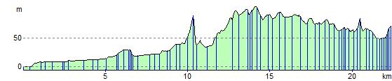
Elevation Profile