Chelmsford to Maldon
12.4 miles (20 km)
![]()
![]() This route starts on the River Can in Chelmsford and follows the river and the Chelmer & Blackwater Canal out of the town centre and into the countryside where you'll then ride on quiet roads to Maldon on the Blackwater Estuary.
This route starts on the River Can in Chelmsford and follows the river and the Chelmer & Blackwater Canal out of the town centre and into the countryside where you'll then ride on quiet roads to Maldon on the Blackwater Estuary.
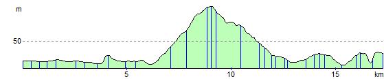
The route is pretty flat with highlights including the spell on the river and some attractive woodland and rural scenery.
Part of the route uses National Cycle Route 13 which runs through the area and eventually takes you to Dereham in Norfolk.
Chelmsford to Maldon Ordnance Survey Map  - view and print off detailed OS map
Chelmsford to Maldon Open Street Map  - view and print off detailed map
Chelmsford to Maldon OS Map  - Mobile GPS OS Map with Location tracking
Chelmsford to Maldon Open Street Map  - Mobile GPS Map with Location tracking
Cycle Routes and Walking Routes Nearby
Elevation Profile