Dorchester to Castle Cary

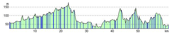
 Follow National Cycle Route 26 north from the lovely town of Dorchester through Sherborne to your destination of Castle Cary Walk in Somerset. The first section takes you along the River Frome to Maiden Newton. You then continue to the villages of Cattistock, Lower Wraxall and Barwick passing the Sutton Bingham Reservoir on your way to Sherborne. From here you head north to Castle Cary passing through the pretty villages of Corton Denham and South Cadbury - home to Cadbury Castle thought to be King Arthur's Camelot by some.
Dorchester to Castle Cary Ordnance Survey Map  - view and print off detailed OS map
Dorchester to Castle Cary Open Street Map  - view and print off detailed map
Dorchester to Castle Cary OS Map  - Mobile GPS OS Map with Location tracking
Dorchester to Castle Cary Open Street Map  - Mobile GPS Map with Location tracking
Pubs/Cafes
You could stop at the Camelot in the little village of South Cadbury for some refreshments on the route. It's very conveniently located just a short stroll from the base of the ancient hill fort. The walls of the pub are even covered with information relating to the history of the castle site. There's a good menu and a lovely garden area to relax in on warmer days. You can find it in the village on Chapel Rd, with a postcode of BA22 7EX for your sat navs.
Cycle Routes and Walking Routes Nearby
Elevation Profile