Dundee to St Andrews
19 miles (30 km)

 Follow National Cycle route 1 along the Firth of Tay on this short, easy ride.
The ride starts on Dundee harbour, crossing the Tay Road Bridge over the Firth of Tay to Newport-on-Tay. You then continue off road to Tayport along the Tay, before heading into Tentsmuir Forest for a lovely wooded section.
A short on road section takes you to Guardbridge before another traffic free path takes you along the Eden Estuary and then through the famous St Andrews golf course to St Andrews.
To extend your ride you can try our nice circular route around St Andrews.
Dundee to St Andrews Ordnance Survey Map  - view and print off detailed OS map
Dundee to St Andrews Open Street Map  - view and print off detailed map
Dundee to St Andrews OS Map  - Mobile GPS OS Map with Location tracking
Dundee to St Andrews Open Street Map  - Mobile GPS Map with Location tracking
Further Information and Other Local Ideas
In Dundee you can link up with National Cycle Route 77 which runs to Pitlochry along a route known as the 'Salmon Run'.
Cycle Routes and Walking Routes Nearby
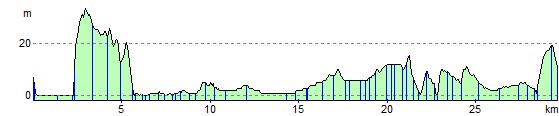
Elevation Profile