Dunfermline to Stirling
37 miles (60 km)

 Travel along National Cycle routes 1 and 76, taking you along the Firth of Forth from Dunfermline to Stirling.
You start of by heading south towards the Firth of Forth via Inverkeithing. Here the route turns west, heading along the Firth of Forth to Stirling on a mixture of on and off road sections. You will pass through Charlestown, Culross, Kincardine and Alloa on the way. Highlights on the ride include the harbour at Charlestown, the strikng Kincardine Bridge and the famous William Wallace Memorial as you approach Stirling.
Dunfermline to Stirling Ordnance Survey Map  - view and print off detailed OS map
Dunfermline to Stirling Open Street Map  - view and print off detailed map
Dunfermline to Stirling OS Map  - Mobile GPS OS Map with Location tracking
Dunfermline to Stirling Open Street Map  - Mobile GPS Map with Location tracking
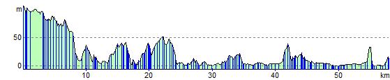
Elevation Profile