Haltwhistle to Tynemouth

 This route is the final leg of 3 making up the Hadrians Cycleway.
The ride has some fabulous scenery as you pass through the counties of County Durham, Northumberland and Tyne and Wear and the city of Newcastle.
This route is the final leg of 3 making up the Hadrians Cycleway.
The ride has some fabulous scenery as you pass through the counties of County Durham, Northumberland and Tyne and Wear and the city of Newcastle.
Route highlights include the Vindolanda and Cordbridge Roman forts, Tyne Green Country Park at Hexham and some lovely traffic free cycling along the River Tyne. The final section takes you through Newcastle on your way to the finish point on the east coast.
Haltwhistle to Tynemouth Ordnance Survey Map  - view and print off detailed OS map
Haltwhistle to Tynemouth Open Street Map  - view and print off detailed map
Haltwhistle to Tynemouth OS Map  - Mobile GPS OS Map with Location tracking
Haltwhistle to Tynemouth Open Street Map  - Mobile GPS Map with Location tracking
Pubs/Cafes
At the end of the route in Tynemouth The Gibraltar Rock is a nice place for refreshments. The pub is located in an excellent spot with views to the coast and the priory. They have a popular carvery and also serve fine fish and chips.
You can find them on East Street with a postcode of NE30 4EB for your sat navs.
Further Information and Other Local Ideas
The Reivers Route links with this trail. The popular coast to coast ride crosses the country from Whitehaven to Tynemouth. The signed trail runs mostly along National Cycle Route 10.
Cycle Routes and Walking Routes Nearby
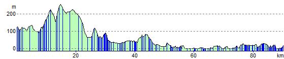
Elevation Profile