Hanson Way
16 miles (25 km)

 Follow the Hanson Way (part of National Cycle Route 5) from Oxford to Didcot via Abingdon.
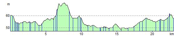
This is a fairly flat route that has plenty of off road sections and a pleasant spell along the River Thames.
Please click here for more information
Hanson Way Ordnance Survey Map  - view and print off detailed OS map
Hanson Way Open Street Map  - view and print off detailed map
Hanson Way OS Map  - Mobile GPS OS Map with Location tracking
Hanson Way Open Street Map  - Mobile GPS Map with Location tracking
Photos

The Hanson Way National Cycle Network information board.

Marker posts and trail view

Abingdon, River Thames
Elevation Profile