Heron Trail
13 miles (21 km)

 This is a lovely circular route around the Hoo Peninsula which is bounded by the River Thames to the north and the River Medway to the south.
The route starts at Higham and follows the trail to Upnoor via the villages of Cliffe and Cooling.
The ride passes near the RSPB Northward Hill Reserve where you can see 150 pairs of grey herons-hence the trail name.
To explore the peninsula on foot you can try the Hoo Peninsula Path or the Saxon Shore Way.
Heron Trail Ordnance Survey Map  - view and print off detailed OS map
Heron Trail Open Street Map  - view and print off detailed map
Heron Trail OS Map  - Mobile GPS OS Map with Location tracking
Heron Trail Open Street Map  - Mobile GPS Map with Location tracking
Cycle Routes and Walking Routes Nearby
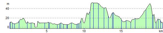
Elevation Profile