Huntingdon to St Neots

 This ride follows National Cycle Route 51 through Cambridgeshire. The route starts outside the tourist information centre in Huntingdon and heads to Brampton passing Hinchingbrooke Country Park. You then continue past Brampton Wood to Grafham Water where a pleasant off road stretch takes you along the water and onto the The Three Shires Way.
Country roads then take you onto St Neots where you will cross the bridge over the River Ouse before finishing near the tourist information centre in the town.
Huntingdon to St Neots Ordnance Survey Map  - view and print off detailed OS map
Huntingdon to St Neots Open Street Map  - view and print off detailed map
Huntingdon to St Neots OS Map  - Mobile GPS OS Map with Location tracking
Huntingdon to St Neots Open Street Map  - Mobile GPS Map with Location tracking
Pubs/Cafes
In St Neots you can visit the splendid River Mill pub for some refreshments after your cycle. The riverside pub has dining area opening out on to the lower mill pond viewing deck. Outside there are lots of picnic tables alongside the upper mill pond and the marina. It's a lovely place to relax on a summer day. You can find it about 1 mile south of the reserve at postcode PE19 8GW.
Cycle Routes and Walking Routes Nearby
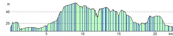
Elevation Profile