Kendal to Settle

 Follow National Cycle route 68 on this challenging but rewarding route which takes you from the Cumbrian Lake District National Park, through the Yorkshire Dales National Park to Settle.
You start by the River Kent in Kendal and follow country roads to Oxenholme and onto Sedbergh. This section has some challenging climbs but splendid views of Lambrigg fell and the River Lune.
From Sedbergh you continue on minor roads crossing the rivers Rawthey and Dee as you enter the Yorkshire Dales National Park. You then pass through Dent and Ingleton where you can see the lovely Ingleton Falls. The final stretch takes you to the finish point in Settle with a lovely spell along the River Ribble.
Kendal to Settle Ordnance Survey Map  - view and print off detailed OS map
Kendal to Settle Open Street Map  - view and print off detailed map
Kendal to Settle OS Map  - Mobile GPS OS Map with Location tracking
Kendal to Settle Open Street Map  - Mobile GPS Map with Location tracking
Further Information and Other Local Ideas
The route passes along part of the epic Pennine Cycleway which can be used to further extend your ride.
The Lakes And Dales Loop passes through Sedbergh. The 196 mile circular ride explores some of the best scenery in the Lake District, the Yorkshire Dales and the River Eden Valley.
Cycle Routes and Walking Routes Nearby
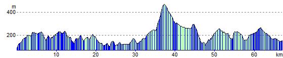
Elevation Profile