National Cycle Route 44 - Ludlow to Shrewsbury
51 miles (82 km)

 This challenging ride takes you through the Shropshire countryside and along the Welsh - English border with splendid views of the Shropshire Hills AONB for most of the ride.
The route starts at Ludlow train station and follows Sustrans National Cycle route 44 and the River Onny into the countryside passing Ludlow Racecourse on the way. You then continue on road to Bishop's Castle and Church Stoke on the Welsh border before passing through the lovely village of Pontesbury. The ride finishes with a pleasant stretch along the River Severn in Shrewsbury before finishing at the train station.
National Cycle Route 44 Ordnance Survey Map  - view and print off detailed OS map
National Cycle Route 44 Open Street Map  - view and print off detailed map
National Cycle Route 44 OS Map  - Mobile GPS OS Map with Location tracking
National Cycle Route 44 Open Street Map  - Mobile GPS Map with Location tracking
Cycle Routes and Walking Routes Nearby
Photos

Ludlow

Farmland at Bishop's Castle

Bishop's Castle High Street

Church Stoke countryside, Powys

View west in the centre of Pontesbury, Shropshire, with the Red Lion Inn ahead and the tower of St George's parish church beyond. The road branching left of the Red Lion is Deanery Close. The road turning sharrply to the right is Hall Bank.

Footpath beside the River Severn in Shrewsbury
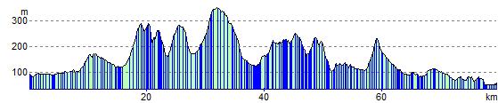
Elevation Profile