Machynlleth to Llanidloes

 Follow National Cycle Route 8 from Machynlleth to Llanidloes and enjoy some splendid scenery.
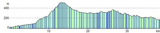
You start off with a lovely run along the River Dulas and some beautiful mountainous scenery around Dylife and Aberhosan. The ride then passes the stunning Clywedog Reservoir as you head into Hafren Forest for a pleasant wooded section. The final stretch takes you along the River Severn into Llanidloes.
Machynlleth to Llanidloes Ordnance Survey Map  - view and print off detailed OS map
Machynlleth to Llanidloes Open Street Map  - view and print off detailed map
Machynlleth to Llanidloes OS Map  - Mobile GPS OS Map with Location tracking
Machynlleth to Llanidloes Open Street Map  - Mobile GPS Map with Location tracking
Pubs/Cafes
The Red Lion in Machynlleth is a nice place to go for some refreshments. The cosy pub has a good menu and is also dog friendly. Outside you can relax in the beer garden on warmer days. Inside there's interesting heavy rock memorabilia on the walls and cosy atmosphere. You can find the pub at 11 Heol Maengwyn with a postcode of SY20 8AA for your sat navs.
In Llanidloes one of the highlights is the historic Angel Inn. The Timber framed former Coaching Inn was built way back in 1748. The Pub has a wealth of character with many original features including Oak beams in the Bar and Lounge. There's a very good menu and some picnic tables outdoors for warmer days. It is located close to the center of Llanidloes on the High Street with a postcode of SY18 6BY for your sat navs.
Cycle Routes and Walking Routes Nearby
Elevation Profile