Manchester to Liverpool
47 miles (75 km)

 This ride takes you along National Cycle Route 62 and the Trans Penine Trail between these two major Northern cities. You start by Manchester Oxford Road station heading south through Chorlton to the River Mersey. A lovely off road section along the river follows, passing Sale Water Park on the way. More off road paths and quiet roads take you through Trafford to Altrincham where you join a lovely traffic free section along the trail and the River Mersey which takes you through Warrington and Widnes.
Quiet roads take you through the outskirts of Liverpool before finishing with another stretch along the Mersey and coming to a stop at the famous Albert Dock.
Manchester to Liverpool Ordnance Survey Map  - view and print off detailed OS map
Manchester to Liverpool Open Street Map  - view and print off detailed map
Manchester to Liverpool OS Map  - Mobile GPS OS Map with Location tracking
Manchester to Liverpool Open Street Map  - Mobile GPS Map with Location tracking
Cycle Routes and Walking Routes Nearby
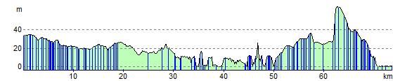
Elevation Profile