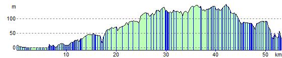
Middlesbrough to Durham
34 miles (55 km)

 Travel from Yorkshire into County Durham along National Cycle Route 1 and 14. You begin near the train station in Middlesbrough and head to Stockton on Tees along an off road section by the River Tees. The route then turns north along the Castle Eden Walkway for more off road riding taking you through the Castle Eden Walkway Country Park. You continue to Haswell where you turn east towards Durham finishing with a pleasant stretch along the River Wear.
Middlesbrough to Durham Ordnance Survey Map  - view and print off detailed OS map
Middlesbrough to Durham Open Street Map  - view and print off detailed map
Middlesbrough to Durham OS Map  - Mobile GPS OS Map with Location tracking
Middlesbrough to Durham Open Street Map  - Mobile GPS Map with Location tracking
Cycle Routes and Walking Routes Nearby
Elevation Profile