Middlesbrough to Thirsk
36 miles (58 km)

 Follow National Cycle Route 65 through North Yorkshire on this challenging ride. The route starts by the railway station in Middlesbrough and heads south into the North York Moors passing through Albert Park, Hemlington Lake and the pretty villages of Hutton Rudby and Swainby.
You will then enjoy some lovely traffic free sections around Cod Beck Reservoir and through Nether Silton Moor. You end the ride by passing through Thirsk and crossing the Cod Beck river before finishing at Thirsk rail station.
This is a rewarding ride with some incredible scenery to enjoy as you pass through the North York Moors.
Middlesbrough to Thirsk Ordnance Survey Map  - view and print off detailed OS map
Middlesbrough to Thirsk Open Street Map  - view and print off detailed map
Middlesbrough to Thirsk OS Map  - Mobile GPS OS Map with Location tracking
Middlesbrough to Thirsk Open Street Map  - Mobile GPS Map with Location tracking
Cycle Routes and Walking Routes Nearby
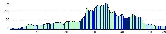
Elevation Profile