Middlesbrough to Whitby
40 miles (65 km)

 This route follows National Cycle route 1 from Middlesbrough to Whitby on the Yorkshire coast.
The route starts by the railway station in Middlesbrough and heads east along the signed National Cycle Route 1 and the River Tees, passing the impressive Transporter Bridge and the Riverside Stadium - home to Middlesbrough FC. You continue to Redcar where you join a traffic free coastal path to Marske by the sea and then onto Saltburn by the sea. The route then joins quiet roads taking you through Skinningrove and Loftus into the North York Moors. There are more splendid coastal views of Runswick Bay and Sandsend to enjoy before finishing in beautiful Whitby.
Middlesbrough to Whitby Ordnance Survey Map  - view and print off detailed OS map
Middlesbrough to Whitby Open Street Map  - view and print off detailed map
Middlesbrough to Whitby OS Map  - Mobile GPS OS Map with Location tracking
Middlesbrough to Whitby Open Street Map  - Mobile GPS Map with Location tracking
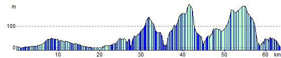
Elevation Profile