Newport to Pontypridd
25 miles (40 km)

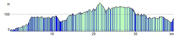
 This ride follows National Cycle routes 47 and 8 from Newport to Pontypridd. Much of this ride is traffic free with spells along the Monmouthshire and Brecon Canal, River Ebbw and the River Taff to enjoy. There are also terrific views of the surrounding countryside as you pass through Risca and Ystrad Mynach as well as the lovely Sirhowy Valley Country Park. The ride finishes with a spell along the River Taff taking you into Pontrypridd.
Newport to Pontypridd Ordnance Survey Map  - view and print off detailed OS map
Newport to Pontypridd Open Street Map  - view and print off detailed map
Newport to Pontypridd OS Map  - Mobile GPS OS Map with Location tracking
Newport to Pontypridd Open Street Map  - Mobile GPS Map with Location tracking
Further Information and Other Local Ideas
Just to the west of Pontypridd there's Barry Sidings Country Park at Trehafod. There's some popular woodland mountain bike trails and lovely walks along the park's streams and waterfalls. There's also good views of the River Rhonnda at the northern end of the park.
Cycle Routes and Walking Routes Nearby
Elevation Profile