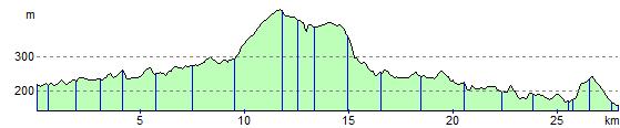
Penistone to Glossop
19 miles (30 km)

 Starting at Penistone railway follow the Trans Pennine Trail to Glossop.
This route is mainly traffic free following off road paths and dismantled railway lines. The final stretch runs between a series of attractive reservoirs (including Winscar Reservoir and Woodhead Reservoir) and hills making for an interesting and varied finish to the ride as you enter the Peak District.
Penistone to Glossop Ordnance Survey Map  - view and print off detailed OS map
Penistone to Glossop Open Street Map  - view and print off detailed map
Penistone to Glossop OS Map  - Mobile GPS OS Map with Location tracking
Penistone to Glossop Open Street Map  - Mobile GPS Map with Location tracking
Cycle Routes and Walking Routes Nearby
Elevation Profile