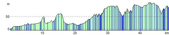
National Cycle Route 53 - Peterborough to Kettering
31 miles (50 km)

 This route takes you from Cambridgeshire to Northamptonshire along National Cycle route 53. The route starts by the railway station in Peterborough and begins with a series of off road sections before country roads take you onto Warmington, Brigstock and finally Kettering. This is a pleasant route passing near several wooded areas around Brigstock and Grafton Underwood.
The Peterborough Green Wheel is a great way of further exploring the city on a signed route. The fairly easy 20 mile circular trail visits Ferry Meadows Country Park, the River Nene Way and the villages of Marholm and Etton.
National Cycle Route 53 - Peterborough to Kettering Ordnance Survey Map  - view and print off detailed OS map
National Cycle Route 53 - Peterborough to Kettering Open Street Map  - view and print off detailed map
National Cycle Route 53 - Peterborough to Kettering OS Map  - Mobile GPS OS Map with Location tracking
National Cycle Route 53 - Peterborough to Kettering Open Street Map  - Mobile GPS Map with Location tracking
Cycle Routes and Walking Routes Nearby
Photos

Peterborough

Peterborough River Nene

Entering Orton Waterville
_-_geograph.org.uk_-_4431818.jpg)
Water Lane (Cycle Path). Traffic free surfaced path through Peterborough's outskirts.

Part of the Nene in Nene Park

Warmington
Elevation Profile