Poole to Gillingham

 Travel from Poole on the Dorset south coast northwards to Gillingham via Shaftesbury and Wimborne Minster.
The route follows National Cycle Route 25 for much of the way and includes a lovely stretch along the River Stour and a variety of quiet paths and lanes through the countryside.
You start in Poole near the train station and follow the path around Holes Bay and Upton Park before joining the Castleman Trailway to Wimborne Minster. From here you follow the River Stour to Blandford Forum via the villages of Pamphill and Shapwick. You then head north west past Stourpaine, Child Okeford, Hambledon Hill, Hod Hill and Shaftesbury before quiet country roads take you to Gillingham.
Poole to Gillingham Ordnance Survey Map  - view and print off detailed OS map
Poole to Gillingham Open Street Map  - view and print off detailed map
Poole to Gillingham OS Map  - Mobile GPS OS Map with Location tracking
Poole to Gillingham Open Street Map  - Mobile GPS Map with Location tracking
Pubs/Cafes
Head to The Baker Arms in Child Okeford for some refreshments on your ride. It's a quintessential Dorset pub located right in the village. The pub dates back to circa 1770 and is perfectly situated at the foot of Hambledon hill. There's a cosy log burner indoors for the winter and a nice beer garden for warm summer days. There's a very good menu and an associated cottage if you need overnight accommodation. You can find the pub at The Cross with a postcode of DT118ED for your sat navs.
Cycle Routes and Walking Routes Nearby
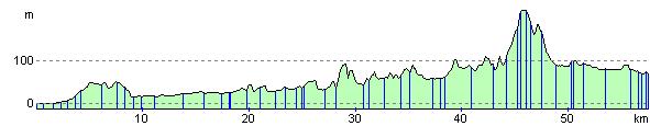
Elevation Profile