Hadrians Cycleway - National Cycle Route 72
174 miles (280 km)

 This is the complete route for the Hadrian's Cycleway which runs from east coast of England to the west coast passing through some fabulous scenery. There's some fascinating history too with views of the famous ancient wall and a visit to a series of Roman forts.
The 172 mile route has been split into three sections which could be completed as day rides. Use the links below to find out more details of the features on each section.
Scroll down for route videos, maps and the complete gpx download.
The route is coincident with the epic Hadrian's Wall Path National Trail which also contains many sections suitable for cyclists.
For a comprehensive guide to the route including accommodation, guide notes and photographs please click here.
Hadrians Cycleway Ordnance Survey Map  - view and print off detailed OS map
Hadrians Cycleway Open Street Map  - view and print off detailed map
Hadrians Cycleway OS Map  - Mobile GPS OS Map with Location tracking
Hadrians Cycleway Open Street Map  - Mobile GPS Map with Location tracking
Further Information and Other Local Ideas
The trail links with the Reivers Route which starts/ends at Tynemouth. The popular coast to coast ride crosses the country from Whitehaven to Tynemouth. The signed trail runs mostly along National Cycle Route 10.
Cycle Routes and Walking Routes Nearby
Photos

Hadrian's Wall National Trail and Hadrian's Cycleway. For nearly 6 km from Drumburgh to beyond Burgh by Sands both Hadrian's Wall National Trail and Hadrian's Cycleway follow the public road. This long straight stretch just to the east of Drumburgh is subject to flooding at very high tides.

Hadrian's Cycleway and Military Road. In order to segregate cyclists on Hadrian's Cycleway from motor traffic on the fast and busy Military Road, this off-road path has been constructed alongside the road for about 1500 metres.

Along the River Tyne in Newcastle

Wylam

Cycleway bridge over the Tipalt Burn This newly constructed bridge carries Hadrian's Cycleway over the Tipalt Burn at its confluence with the Pow Charney Burn near Thirwall Castle at Greenhead.

Hadrian's Wall National Trail at Gilsland

Hadrian's Way at Walker Riverside Park. Hadrian's Way is a largely traffic-free route along the north side of the Tyne from western to eastern boundaries of the City of Newcastle-upon-Tyne. At this point, Hadrian's Way finally leaves the river bank and doubles back up the hill. East of here the Way follows the course of an old railway as far as Wallsend.

Hadrian's Wall National Trail near Birdoswald.
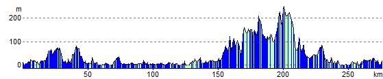
Elevation Profile