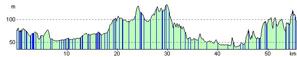
Redhill to Tunbridge Wells
36 miles (58 km)

 Starting in Redhill first travel south through Gatwick airport (easier and more pleasant than it sounds!) and then onto the off road Worth Way, Forest Way and Sussex Border Path that will take you through East Grinstead and some lovely countryside before finishing in Royal Tunbridge Wells.
The ride follows National Cycle Route 21 and has a number of traffic free sections making it an attractive, leisurely ride.
Redhill to Tunbridge Wells Ordnance Survey Map  - view and print off detailed OS map
Redhill to Tunbridge Wells Open Street Map  - view and print off detailed map
Redhill to Tunbridge Wells OS Map  - Mobile GPS OS Map with Location tracking
Redhill to Tunbridge Wells Open Street Map  - Mobile GPS Map with Location tracking
Cycle Routes and Walking Routes Nearby
Elevation Profile