Rochdale to Todmorden

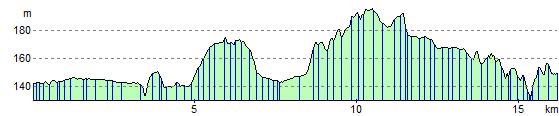
 This lovely ride follows National Cycle Route 66 from Greater Manchester into Yorkshire wih terrific views of the Pennines. The route starts by the railway station in Rochdale and soon joins the Rochdale canal for an easy traffic free run to Smithy Bridge. Here you will pass Hollingworth Lake which has watersports and a nature reserve to enjoy.
The route continues through Littleborough and Walsden following the canal as you go. You finish by the railway station in Todmorden.
Rochdale to Todmorden Ordnance Survey Map  - view and print off detailed OS map
Rochdale to Todmorden Open Street Map  - view and print off detailed map
Rochdale to Todmorden OS Map  - Mobile GPS OS Map with Location tracking
Rochdale to Todmorden Open Street Map  - Mobile GPS Map with Location tracking
Pubs/Cafes
Right next to Hollingworth Lake is the splendid Wine Press. This contemporary British Restaurant includes a lovely outdoor seating area where you can enjoy fine views over the lake with your lunch. There's also an attractive modern interior for cooler days. The pub is also dog friendly.
Cycle Routes and Walking Routes Nearby
Elevation Profile