St Austell to Par

 This short ride takes you along National Cycle Route 3 from St Austell to Par.
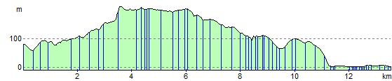
Much of this pleasant route is traffic free with the finish point at the attractive Par sands making it a nice leisurely afternoon ride. The route starts near St Austell train station following off road paths to the China clay works near Trethurgy before heading south east past the Eden Project which is well worth a visit. You'll then continue to St Blazey before the finish point on the beach at Par Sands.
St Austell to Par Ordnance Survey Map  - view and print off detailed OS map
St Austell to Par Open Street Map  - view and print off detailed map
St Austell to Par OS Map  - Mobile GPS OS Map with Location tracking
St Austell to Par Open Street Map  - Mobile GPS Map with Location tracking
Further Information and Other Local Ideas
The route passes close to the popular Luxulyan Valley, a designated World Heritage Site. The valley is one of the highlights of the area with nice trails along the River Par, a series of historical industrial remains and the impressive Treffry Viaduct to see.
Cycle Routes and Walking Routes Nearby
Elevation Profile