Stevenage to Baldock
9 miles (15 km)

 This route starts in Stevenage near the train station and heads north along National Cycle Route 12 and the Hertfordshire Way to Baldock via Graveley. Much of the route is off road making it a plesant, easy short route.
Stevenage to Baldock Ordnance Survey Map  - view and print off detailed OS map
Stevenage to Baldock Open Street Map  - view and print off detailed map
Stevenage to Baldock OS Map  - Mobile GPS OS Map with Location tracking
Stevenage to Baldock Open Street Map  - Mobile GPS Map with Location tracking
Cycle Routes and Walking Routes Nearby
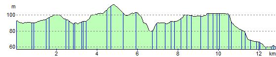
Elevation Profile