Stoke-On-Trent to Stone
9 miles (15 km)

 This short easy route follows the Trent & Mersey Canal and National Cycle Route 5 from Stoke-On-Trent to Stone. The route starts and finishes at the train stations in each place and takes place largely on a long traffic free section running by the canal.
Highlights on the route include passing the Brittania Stadium, home to Stoke City FC and a pleasant stretch by Barlaston Park.
Stoke-On-Trent to Stone Ordnance Survey Map  - view and print off detailed OS map
Stoke-On-Trent to Stone Open Street Map  - view and print off detailed map
Stoke-On-Trent to Stone OS Map  - Mobile GPS OS Map with Location tracking
Stoke-On-Trent to Stone Open Street Map  - Mobile GPS Map with Location tracking
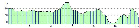
Elevation Profile