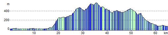
Swansea to Pontypridd
42 miles (68 km)

 Travel through the beautiful Rhondda Valley along National Cycle route 47 and enjoy fabulous views of the Brecon Beacons.
This is a challenging but rewarding ride with several traffic free sections and some spectacular scenery.
You can continue your ride along National Cycle Route 47 which runs east to Newport or west to Fishguard on the coast.
Swansea to Pontypridd Ordnance Survey Map  - view and print off detailed OS map
Swansea to Pontypridd Open Street Map  - view and print off detailed map
Swansea to Pontypridd OS Map  - Mobile GPS OS Map with Location tracking
Swansea to Pontypridd Open Street Map  - Mobile GPS Map with Location tracking
Further Information and Other Local Ideas
Just to the west of Pontypridd there's Barry Sidings Country Park at Trehafod. There's some popular woodland mountain bike trails and lovely walks along the park's streams and waterfalls. There's also good views of the River Rhonnda at the northern end of the park. The park makes a nice small detour from the route and has a good bike centre with hire and trail information.
Cycle Routes and Walking Routes Nearby
Elevation Profile