Telford and Ironbridge Circular
14 miles (22 km)

 This lovely circular route starts in Telford and follows the off road Silkin Way south to Ironbridge on the River Severn. You will then follow the Severn Way along the river before crossing the iconic bridge and heading back north to Telford.
Telford and Ironbridge Circular Ordnance Survey Map  - view and print off detailed OS map
Telford and Ironbridge Circular Open Street Map  - view and print off detailed map
Telford and Ironbridge Circular OS Map  - Mobile GPS OS Map with Location tracking
Telford and Ironbridge Circular Open Street Map  - Mobile GPS Map with Location tracking
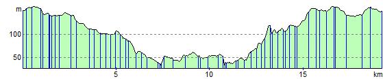
Elevation Profile