Tongue to Thurso
43 miles (70 km)

 Travel along the beautiful north coast of Scotland on National Cycle route 1 and enjoy fabulous coastal views and a succession of pretty coastal towns and villages.
The route starts in Tongue on the stunning Kyle of Tongue and follows quiet country roads towards the coast. You then head east along the coast passing through Invernaver, Armadale and Strathy with lovely views at Torrisdale and Armadale Bays. The ride finishes in the coastal town of Thurso.
Tongue to Thurso Ordnance Survey Map  - view and print off detailed OS map
Tongue to Thurso Open Street Map  - view and print off detailed map
Tongue to Thurso OS Map  - Mobile GPS OS Map with Location tracking
Tongue to Thurso Open Street Map  - Mobile GPS Map with Location tracking
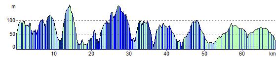
Elevation Profile