Truro to St Austell
31 miles (50 km)

 Follow National Cycle Route 3 from Truro through some spectacular Cornish scenery and a beautiful coastal stretch to the popular town of St Austell. The route starts with a lovely off road stretch by the Truro river before boarding the King Harry Ferry to take you across the river Fal. You continue to the coast with fantastic views of Pendower and Carne Beach before coming to the beautiful Portloe (pictured below). The route then passes through St Michael Caerhays before arriving at the beautiful port of Mevagissey and the nearby world renowned Lost Gardens of Heligan.
A short on road stretch then takes you onto the finish point at St Austell.
Truro to St Austell Ordnance Survey Map  - view and print off detailed OS map
Truro to St Austell Open Street Map  - view and print off detailed map
Truro to St Austell OS Map  - Mobile GPS OS Map with Location tracking
Truro to St Austell Open Street Map  - Mobile GPS Map with Location tracking
Cycle Routes and Walking Routes Nearby
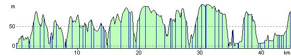
Elevation Profile