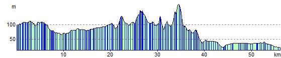
Whitchurch to Chester
36 miles (58 km)

 This route starts by the railway station in Whitchurch and follows National Cycle Route 45 through Shropshire and into Cheshire. You will first head north east towards Wrenbury where you cross the Llangollen Branch of the Shropshire Union Canal. The route then continues east towards the lovely Cholmondeley Castle which is well worth a visit and an ideal place to stop for refreshments. From there the ride continues on road to Bickerton and Peckforton where you will pass Beeston Castle, Bickerton Hill and Peckforton Castle and Peckforton Hills.
The final stretch towards Chester follows the Shropshire Union Canal for much of the way.
You finish at the train station in Chester.
Whitchurch to Chester Ordnance Survey Map  - view and print off detailed OS map
Whitchurch to Chester Open Street Map  - view and print off detailed map
Whitchurch to Chester OS Map  - Mobile GPS OS Map with Location tracking
Whitchurch to Chester Open Street Map  - Mobile GPS Map with Location tracking
Cycle Routes and Walking Routes Nearby
Elevation Profile