Wolverhampton to Telford
22 miles (35 km)

 This route follows National Cycle Route 81 through the West Midlands to Shropshire. The route starts in the centre of Wolverhampton and heads through the town and West Park to join the Staffordshire and Worcestershire canal towpath which takes you towards Bilbrook. Country roads then take you onto Codsall, Albrighton and Shifnal before a short off road section takes you past Priorlsee lake and then into Telford.
Wolverhampton to Telford Ordnance Survey Map  - view and print off detailed OS map
Wolverhampton to Telford Open Street Map  - view and print off detailed map
Wolverhampton to Telford OS Map  - Mobile GPS OS Map with Location tracking
Wolverhampton to Telford Open Street Map  - Mobile GPS Map with Location tracking
Cycle Routes and Walking Routes Nearby
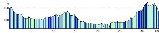
Elevation Profile