Aber Falls Walk

 Follow a splendid walking trail up to the beautiful Aber Falls on this circular walk in the Snowdonia National Park. Aber Falls (Rhaeadr Fawr in Welsh) is located near the village of Abergwyngregynin Gwynedd. The walk starts at the car park at Bont Newydd and follows the North Wales Path along the Afon Rhaeadr Fawr to the 120 ft high falls. You'll pass through the stunning scenery of the Coedydd National Nature Reserve with its wonderful woodland and mountain scenery. There's also a variety of wildlife to look out for including treecreepers, sparrowhawks, woodpeckers, tree pipits, skylarks and buzzards. If you're lucky you may spot polecats, stoat and lizards too. The walk involves a moderate climb but you're rewarded with magnificent views of the surrounding countryside and mountains from the high points.
For a shorter route to the falls see our Aber Falls Easy Walk.
Postcode
LL33 0LP - Please note: Postcode may be approximate for some rural locationsAber Falls Ordnance Survey Map  - view and print off detailed OS map
Aber Falls Open Street Map  - view and print off detailed map
Aber Falls OS Map  - Mobile GPS OS Map with Location tracking
Aber Falls Open Street Map  - Mobile GPS Map with Location tracking
Pubs/Cafes
The Aber Falls Cafe is a nice choice for some refreshments after your walk. The cafe supplies fine cakes, specialty coffees, toasted panini and luxury champagne high teas. There's a nice bright conservatory and a veranda with a lovely view of the garden. You can find the cafe in Abergwyngregyn with a postcode of LL33 0LD for your sat navs.
Dog Walking
The falls are a nice place for a dog walk but it's probably best to keep them on leads as there are ponies and livestock near the trail. The cafe mentioned above is also dog friendly.
Further Information and Other Local Ideas
The North Wales Path provides good opportunities for extending your walking in the area. The waymarked trail runs right past Abergwyngregyn and could be followed west to visit Penrhyn Castle and Bangor. The 19th-century neo-Norman castle has some nice easy walking trails to follow around the woodland and parkland. The noteworthy Lon Las Ogwen cycle route also starts just to the east of Bangor at Porth Penrhyn. The off road trail will take you south through Snowdonia to the beautiful Llyn Ogwen, passing the fascinating Penrhyn Quarry at Bethesda and the stunning glacial valley of Nant Ffrancon on the way. It runs mostly along old railway paths and the River Ogwen before finishing at the lake and waterfall. The route uses part of National Cycle Route 5 and is also suitable for walkers.
If you were to head south east along the path from the car park, you would soon come to a different public footpath. This leads south east along the Afon Anafon to the pretty Llyn Anafon. It's a very peaceful and beautiful spot and makes a nice extension to the walk.
The falls are located close to the town of Llanfairfechan. There's a train station here so you could visits the falls via public transport. There are regular (two-hourly) through services to Chester via Colwyn Bay, Rhyl, Prestatyn and Flint. After arrival at Chester, most trains go forward to either Cardiff Central or Birmingham International.
The coastal town is also a pleasant place for a stroll, with its beautiful blue flag beach, Victorian cottages, boating lake, promenade and bird reserve. You could visit the falls from the town by following the North Wales Path south and then west through the countryside. It's about a 3-4 mile walk from the town.
Cycle Routes and Walking Routes Nearby
Photos

Aber Falls. The falls are formed as the Afon Goch plunges about 120 feet (37 m) over a sill of ancient igneous rock in the foothills of the Carneddau mountain range.

The river in spate above Aber Falls

View across to the foot of Rhaeadr-Fawr

View of the falls from below. People like to bathe in the plung pool though care must be taken on the slippery rocks.

Bronze age burial cairn, near the falls. This rather unprepossessing piece of rough ground and stones in the middle of a patch of cleared forest is a bronze age burial cairn (one of various such remains in the area). Moel Wnion can be seen in the background, together with three lines of pylons which carry transmission lines over the hills rather than along the very restricted coastal route. Several standing stones and cairns can also be seen nearby.

Beginning of the trail from the car park to the falls. It had rained heavily overnight, hence the puddles on the path, and the 'steaming' from the trees.

Wider view of the valley of Afon Rheadr Fawr with peaks of Foel Ganol in the far distance.

The falls viewd from the Marian Rhaeadr-fawr scree slope
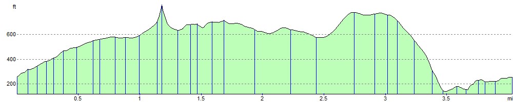
Elevation Profile