Austwick Walks

 The delightful little village of Austwick is positioned nicely in the Yorkshire Dales National Park.
This circular walk from the village visits the fascinating Norber Erratics before heading to the nearby village of Clapham. The walk runs for just over 4 miles with a moderate climb on the way.
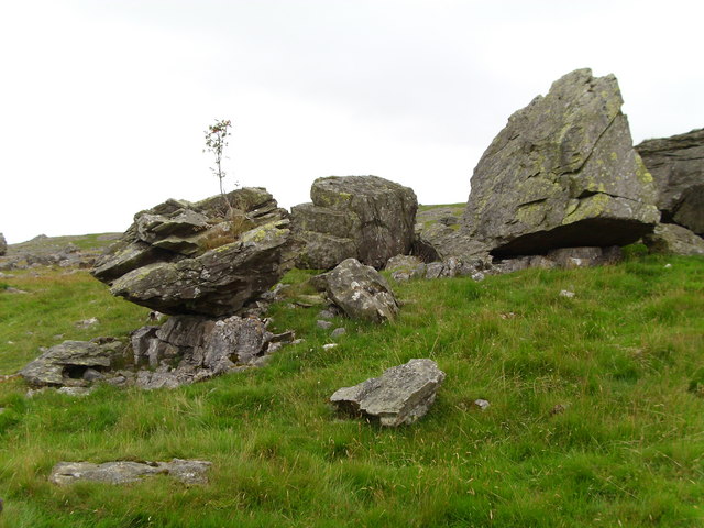
The walk starts in the village and follows a footpath north past Austwick Hall and Town head before climbing up to Norber Erratics. Here you'll find a set of glacial erratic boulders which were probably deposited by melting ice sheets at the end of the last ice age, around 12,000 years ago. The area includes some wonderful limestone scenery and fine views over the dales countryside.
You then descend to the south west to pick up Thwaite Lane and follow it west into Clapham. The popular village has been home to the Farrer family who established their Ingleborough estate in the 18th century. The family owns, and is responsible for, much of the land, walls, woods, fields and moors of the village, surrounding countryside and farms.
After exploring the village you can pick up another public footpath and follow it east back into Austwick.
Austwick Ordnance Survey Map  - view and print off detailed OS map
Austwick Open Street Map  - view and print off detailed map
Austwick OS Map  - Mobile GPS OS Map with Location tracking
Austwick Open Street Map  - Mobile GPS Map with Location tracking
Walks near Austwick
- Norber Erratics - This walk climbs to this geologically significant set of glacial erratic boulders in the Yorkshire Dales
- Ingleborough Mountain - Climb to one of Yorshire's Three Peaks, Ingleborough stands at a height of 723 metres (2,372 ft)
- Ribblehead Viaduct - Enjoy a circular walk around this famous landmark in the Yorkshire Dales
- Whernside - Climb to the highest point in North Yorkshire on this challenging circular walk in the Yorkshire Dales
- Whernside Ingleborough Circular Walk - This challenging circular walk visits two of the famous Yorkshire Three Peaks
- Pennine Bridleway - This fabulous 120 mile long trail runs through the beautiful Derbyshire Peak District, through Lancashire and on into Yorkshire.
It is suitable for mountain bikers, horse riders and walkers taking you on a tour through some of the most beautiful parts of the country - Ingleborough Walk from Clapham - This walk climbs to Ingleborough Cave and Ingleborough Mountain from the Yorkshire village of Clapham
- Ingleton Falls - One of the loveliest walks in England, this circular trail visits a series of beautiful waterfalls in Ingleton in the Yorkshire Dales
- Feizor - This little hamlet in the Yorkshire Dales is known for some splendid limestone scenery
- Stainforth Force - Enjoy a short walk to Stainforth Force waterfall from the North Yorkshire village of Stainforth.
Start the walk from the main parking area in the village and head west, crossing the bridge over the river - Giggleswick - This picturesque village is located close to Settle in the Craven district of North Yorkshire
- Settle Caves and Waterfalls Walk - This beautiful circuit around Settle visits a series of rushing waterfalls, pretty becks, limestone outcrops and mysterious caves
- Settle Riverside Walk - This walk takes you along the River Ribble from the Yorkshire town of Settle to its near neighbour at Stainforth.
Pubs/Cafes
On the route you could stop of at the Old Manor House in Clapham. The historic mullioned farmhouse was built in 1640 and has since been renovated to house the Clapham Bunkhouse (Group Accommodation) and The Reading Room Cafe/Bar licensed to sell hot food, alcohol, arts, crafts and gifts. It's got a great menu and sells some fine real ales. You can find it on Church Avenue at postcode LA2 8EQ.
The New Inn is another good option, set in an 18th-century coaching inn overlooking the Clapham Beck (Postcode:LA2 8HH). There's also the Game Cock back in Austwick which is a traditional Dales pub on the village green, serving good British food with a French/Mediterranean twist (postcode: LA2 8BB).
Further Information and Other Local Ideas
Just over a mile to the south east of the village you will find the little hamlet of Feizor. It's a lovely hidden gem of a place with fine limestone scenery and a delightful local tea room with a falconry. The circular Feizor Walk starts from the hamlet and visits Austwick before heading to the picturesque Stainforth Force Waterfalls on the River Ribble.
For more walking ideas in the area see the Yorkshire Dales Walks page.


