Chiltern Link

 Travel through the beautiful Chiltern Hills on this path which links the Chess Valley Walk and the Ridgeway National Trail. The route runs for 8 miles between Wendover and Chesham passing through some really splendid countryside and the lovely Wendover Woods.
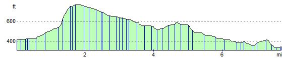
Here you can enjoy a climb to Haddington Hill, the highest point in the Chilterns.
Chiltern Link Ordnance Survey Map  - view and print off detailed OS map
Chiltern Link Open Street Map  - view and print off detailed map
Chiltern Link OS Map  - Mobile GPS OS Map with Location tracking
Chiltern Link Open Street Map  - Mobile GPS Map with Location tracking
Pubs/Cafes
In Wendover Woods you could stop off at the new on site Wendover Woods Cafe, located right next to the main car park, about half a mile north of the path. There's lots of tables outside where you can enjoy a meal with great views of the trees. It's a lovely spot to take the weight of your feet. They serve a wide range of tasty hot and cold locally sourced food (including daily specials), delicious cakes and freshly baked pastries, as well as a range of hot and cold Fairtrade drinks. Just to the north of the cafe there's a bookable BBQ area if you fancy bringing along your own food to cook. Just email wendoverbbq@forestryengland.uk for more info.
Further Information and Other Local Ideas
For cyclists Wendover makes a good entry point for the epic Chilterns Cycleway. The signed circular trail runs for about 170 miles through the Chilterns AONB on quiet country lanes, visiting a series of delightful villages.
Cycle Routes and Walking Routes Nearby
Elevation Profile